Good west swells continue with lighter winds for the Mid
South Australian Surf Forecast by Craig Brokensha (issued Wednesday July 19th)
Best Days: South Coast today, both coasts Friday, South Coast Saturday morning, Mid Coast Sunday, both coasts Monday and Tuesday
Features of the Forecast (tl;dr)
- Small, leftover surf tomorrow with strong N/NW tending W/NW winds ahead of a late PM W/SW change
- Moderate sized W/SW groundswell and mid-period swell Fri with variable tending NW winds on the Mid, W/NW-NW all day down South
- Easing surf Sat with fresh NW tending W/NW winds, then stronger W/SW-SW into the afternoon
- Moderate sized, reinforcing W/SW swell Sun with strong S winds (tending S/SE at times on the Mid)
- Easing surf Mon with local offshore winds and weak sea breezes
- Mod-large W/SW groundswell Tue with E/NE tending NW winds on the Mid, N/NE tending variable down South
Recap
Early favourable NW winds on the South Coast favoured Middleton yesterday with plenty of swell holding 3ft, but conditions deteriorated as a strong S/SW change moved through. The Mid Coast was a bumpy 2ft but winds became lighter through the day offering workable conditions for the keen along with a few bigger sets.
This morning the Mid Coast was clean early along with 2ft sets but winds are now freshening from the N'th, while the South Coast is clean and 4ft with the offshore wind ironing out some early lump. The South Coast will continue to clean up with persistent offshore winds as the swell eases, while the Mid Coast will become more choppy, also with a drop in size.

Decent size on the Mid yesterday arvo

Solid South Coast this morning
This week and next (Jul 20 - 28)
Tomorrow morning looks to be a low point in swell energy and strong N/NW winds will shift W/NW as a mid-latitude front clips us, bringing a W/SW change late afternoon. Middleton looks to be back to 2ft max on the sets (1-2ft most likely), tiny on the Mid Coast, making it a lay day.
Late in the day we may see hints of a new W/SW groundswell but the bulk of the energy is due on Friday, mixed in with some mid-period stuff.

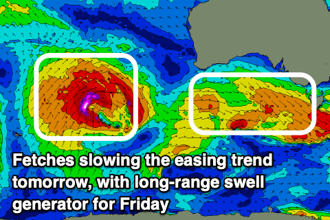
The groundswell was generated by the initial stages a strong low in the southern Indian Ocean on Monday. This low generated a fetch of gale to severe-gale winds in our distant swell window, weakening while pushing east across Western Australia and splitting in two.
This is now seeing a fetch of strong to gale-force W/SW winds to the south of Western Australia, from the southern developments, while the northern split is expected to dip south-east through the Bight today, clipping us tomorrow afternoon, bringing the change.
A mix of mid-period and groundswell energy will fill in through the day with the Mid Coast coming in at 2-3ft with Middleton offering inconsistent 4ft+ sets (biggest and most consistent from Day St).
Winds look favourable for both coasts on Friday, variable on the Mid, tending NW through the day but only moderate in strength with W/NW-NW winds persisting all day down South.
A temporary drop in swell is likely on Saturday morning ahead of some reinforcing mid-period W/SW swell late in the day but more so Sunday.
This is being generated by a healthy mid-latitude frontal system moving in from the southern Indian Ocean, generating a persistent fetch of strong to gale-force W/NW winds.
Inconsistent 2ft sets are due to persist on the Mid Coast (possible rare bigger one with the tide Sunday) with 3-4ft surf across Middleton but the main issue will be the local winds.
The front is expected to clip us on Saturday with fresh, morning NW winds due to shift W/NW ahead of a strong afternoon W/SW change.
Sunday looks dicey with strong, easing S'ly winds down South and cross-shore S-S/SE winds across the Mid, favouring protected spots.

Monday will become cleaner as the swell eases under light, local offshore winds ahead of weak sea breezes.
Now, moving into Tuesday we've got our strong, inconsistent W/SW groundswell that was mentioned on Monday due to fill in, peaking later in the day.
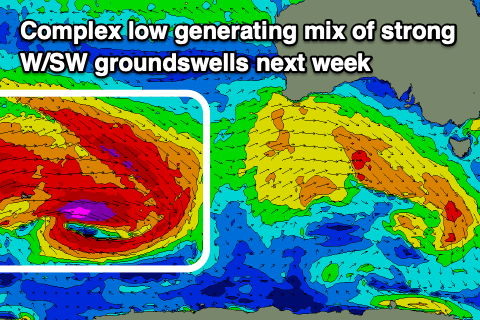
The source will be a broad, complex low moving across the Heard Island region tomorrow and Friday.
A great pre-frontal fetch of gale to severe-gale W/NW winds will be closely followed by similar strength W/SW winds, weakening while pushing east towards a line drawn south of Western Australia.
A moderate to large sized, inconsistent mix of W/SW groundswells are due Tuesday, offering inconsistent 2ft+ sets on the Mid Coast and stronger 4-6ft waves across Middleton along with E/NE tending N/NW winds on the Mid and N/NE tending variable winds down South. More on this Friday.


Comments
Any idea when the Triggs cam will be back online? Cheers.
Got a maintenance trip lined up early August, should be done then, thanks for your patience.
I came to type out the same question....I can tell alot from the same cam and often just let it play on my TV at home as a window to the coast.