Fun weekend on the Mid, best down South Sunday
South Australian Surf Forecast by Craig Brokensha (issued Friday July 14th)
Best Days: Mid Coast tomorrow, Sunday, Monday, Wednesday, South Coast Sunday, Monday, Tuesday morning, Wednesday
Features of the Forecast (tl;dr)
- Temp low poing in swell Fri AM, ahead of a W/SW groundswell for the PM, holding Sat
- E tending S/SW winds on the Mid Sat (S/SE later), mod-fresh S down South
- Moderate sized SW groundswell building Sun (peaking PM) with local offshore winds ahead of weak sea breezes
- Slowly easing surf Mon with local offshore winds and variable sea breezes
- New moderate sized mix of W/SW swells Tue with strong W/NW tending SW winds before lunch
- Easing surf Wed with fresh NE winds
Recap
Great conditions yesterday morning with an inconsistent peak in W/SW groundswell to 3-4ft across Middleton, windy into the afternoon and a little slower. Today the swell is holding 3ft off Middleton with strong offshore winds.
The Mid Coast has held between 2ft to occasionally 3ft both yesterday and today though conditions were best at dawn, deteriorating through the days under strengthening N'ly winds.


Glamour conditions yesterday

Windier but still fun today
This weekend and next week (Jul 15 - 21)
The weekend is looking really fun across the Mid Coast thanks to an improvement in the local winds along with fun pulses of W/SW swell.

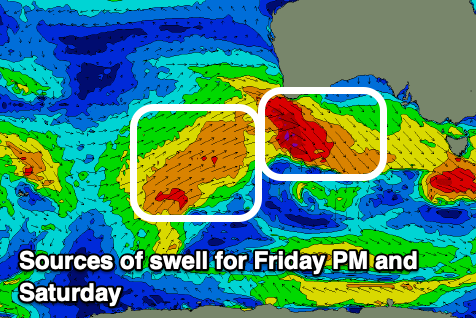
Into this afternoon, a good pulse of reinforcing W/SW swell energy is due, holding tomorrow. This has been generated by pre-frontal, strong to gale-force W/NW winds pushing under WA mid-week, while today we've got a weaker trailing fetch of W/SW winds which should maintain fun surf tomorrow.
More consistent 2-3ft sets should be seen on the Mid Coast this afternoon/evening, with a very late drop in wind speeds.
Tomorrow should hold 2-3ft on the favourable parts of the tide and conditions will be excellent with a light offshore E'ly breeze, giving into S/SW sea breezes, then back to the S/SE late in the day.
The South Coast will be bumpy with a moderate (possibly fresh at times) S-S/SE wind due after a front clips us early morning and the swell should come in at a fun 3-4ft across the Middleton stretch.
Sunday looks better for the South Coast with winds tending to the N/NW through the morning, shifting weak W/SW into the afternoon while the Mid should see E/NE-NE winds ahead of weak W/SW sea breezes.

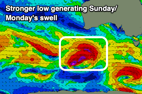
A good pulse of new SW groundswell is due to fill in Sunday, generated by a great looking frontal system that's due to move in under the country today and tomorrow. A fetch of gale to severe-gale W/NW winds will be closely followed by W/SW gales, racing east and then weakening while pushing across Tasmania tomorrow evening.
This should produce a moderate + sized SW groundswell for Sunday, building to 5ft across Middleton into the afternoon while maintaining 2ft waves on the Mid Coast.
The swell should ease slowly Monday from 4-5ft across Middleton and 2ft on the Mid with favourable winds. A N/NW breeze is due all day down South with NE tending light N/NW winds in the gulf.
A mix of moderate sized, inconsistent W/SW swells are due through Tuesday next week, generated by strong continued frontal activity in the southern Indian Ocean.
This will maintain fun surf in the 3-4ft range across Middleton with infrequent 2ft sets on the Mid Coast, easing Wednesday.
Winds will deteriorate Tuesday as a front clips us with early strong W/NW winds, shifting strong SW through the mid-late morning, clean again across both coasts Wednesday morning as wind shift back to the NE.
Beyond this the outlook remains active, but check back here Monday for the latest. Have a great weekend!


Comments
Interested to know why it was so average on the mid (other than the obvious answer.. it's the mid) this morning... Was it because of the wind speed out to sea that deteriorated the swell so much..average tides??.the forecast was for "excellent " windwise ... I'm just interested not blaming.. I went for a skate anyway so all good ..as no rain till lunch
Yeah, I thought conditions were going to be much better but actually winds just went variable after being N'ly all night so it was very lumpy and average. Looks like it got better and better through the day but using the word excellent without a moderate offshore wind was an error.