Excellent weekend of surf
South Australian Surf Forecast by Craig Brokensha (issued Wednesday June 7th)
Best Days: South Coast Friday morning, Saturday, Sunday, Monday South Coast, Tuesday South Coast
Features of the Forecast (tl;dr)
- Building W/NW windswell on the Mid Coast tomorrow with strong NW tending W/NW winds
- Moderate sized, mid-period W/SW swell building Fri down South, steady all day on the Mid, peaking Sat AM
- Gusty W/SW winds Fri, likely W/NW down South early AM
- Large, long-period but inconsistent SW groundswell building Sat, peaking late PM with N/NW winds (N/NE-N/NW on the Mid)
- Large, easing groundswell Sun with N winds (N/NE on the Mid)
- Easing swell Mon with stronger N/NE winds
- Moderate sized W/SW swell building Tue with W/SW winds, easing Wed
Recap
The swell has slowly been fading the last couple of days, fun and to 1-2ft across Middleton yesterday, best on the magnets and a little smaller this morning. The Mid Coast has failed to go flat with a tiny hint of background energy keeping beginners happy.

Perfect South Coast conditions yesterday PM
This week and weekend (Jun 8 - 11)
Tomorrow will remain in the small to tiny size range down South (with building windswell across the Mid Coast) ahead of a building mid-period W/SW swell on Friday that’s due to peak Saturday morning.
This will be the precursor to a much larger and stronger SW groundswell that’s due to build through Saturday, peaking into the late afternoon, then easing Sunday.

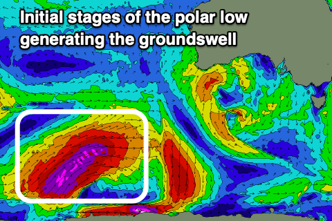
This whole swell evolution from west to south-west will be linked to the same storm, with it initially developing as a strong polar low in the Heard Island region.
The low generated a fetch of severe-gale to storm-force W’ly winds in our far swell window and is now projecting north-east while generating slightly weaker gale to severe-gales.
We’ll see the remnants of the low pushing east through the Bight as a frontal progression, weakening while moving across us tomorrow afternoon/evening, and this will be the source of the mid-period W/SW swell energy, with the less consistent but stronger, larger groundswell due to follow.
On the Mid Coast, strong NW tending W/NW winds will kick up a building windswell tomorrow, from 2ft in the morning to 2-3ft through the afternoon. The South Coast will remain minimal in size and not overly great.
On Friday though, the mid-period energy from a broad and elongated fetch of strong to gale-force W/SW winds should build to from 3-4ft across Middleton to a more consistent 4ft into the afternoon, while the Mid Coast should hold in the 2-3ft range, similar Saturday morning.

The less consistent but large, long-period SW groundswell is due to build over the top of the mid-period energy Saturday, with a peak into the late afternoon.
Strong, building sets to 6-8ft are due later afternoon, easing back from 5-6ft on Sunday morning, 2ft on the Mid Coast.
Locally winds will be worst Friday, great for the weekend. A gusty W/SW breeze is due Friday, likely W/NW in the morning around Victor, with Saturday seeing excellent N/NW winds down South, N/NE tending N/NE and then back the N/NE on the Mid. Similar N’ly winds should play out Sunday as the swell eases, stronger N/NE on Monday as the swell eases back from 3ft+. The Mid Coast looks to become tiny into Monday.
Longer term a fun new mid-period W/SW swell is on the cards for Tuesday/Wednesday but with westerly winds. More on this Friday.

