Plenty of swell with tricky winds this week
South Australian Surf Forecast by Craig Brokensha (issued Monday May 15th)
Best Days: South Coast this afternoon and early tomorrow, Mid Coast all day, South Coast for the keen Wednesday morning and early Thursday, South Coast Friday morning and early Sunday
Features of the Forecast (tl;dr)
- Mod-large S/SW groundswell peaking tomorrow with early local offshore winds, shifting strong S mid-AM down South, fresh S/SE into the PM on the Mid Coast
- Easing surf Wed with E/NE tending SE winds down South, clean in the AM on the Mid
- Smaller Thu with early W/NW winds, tending S/SW mid-AM
- Building mix of S/SW swells Fri PM with N/NW tending fresh W/SW winds into the PM
- Moderate sized swell Sat with fresh SW winds
- Similar swell Sun with early W/NW winds, shifting SW
Recap
On a pumping May day of surf, we lost one of our own. Sadly Simon was taken while doing what all of us love. Thoughts go out to the family, friends and those who were also in the water as well as the greater South Australian surfing community, which is very tight knit.
Saturday provided excellent waves across the Mid Coast with clean conditions and a strong peak in W/SW groundswell that pulsed to 3ft+. The swell eased back through Sunday with cleaner conditions down South, providing options for all.
This morning we've seen the swell drop further as light N'ly winds favour the South Coast, slightly wind affected and to 1ft on the Mid. A new pulse of SW groundswell should be seen into the late afternoon along with weak sea breezes.

Glassy options today
This week and weekend (May 16 - 21)
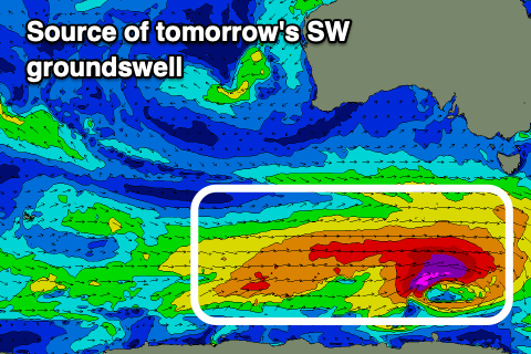
This afternoon's building SW groundswell is expected to peak tomorrow out of the S/SW, generated a strong polar frontal progression that developed over the weekend, with a fetch of pre-frontal W/NW gales strengthening further to the severe-gale range, south-west of Tasmania last night.

The progression was a touch faster than ideal, to the east through our swell window, but with the strongest stages generated nicely in our southern swell window, we should see a moderate -large S/SW groundswell peaking tomorrow down South to 4-5ft across Middleton with the rare 6ft'er on the magnets around town. It'll be bigger at the exposed beaches to the west. The Mid Coast should see inconsistent 2ft sets on the favourable parts of the tide, with both regions easing into Wednesday.
Now, locally winds will be best early for the South Coast and W/NW ahead of a strong S'ly change mid-morning as a front clips us. The Mid should be decent all day with light, variable offshore winds, strengthening from the S/SE into the afternoon.
As the swell slowly eases on Wednesday winds should swing back E/NE down South through the morning but it's likely to be lumpy and not great. The Mid looks clean but easing from 1-1.5ft.
Thursday is a touch dicey again down South with early W/NW winds, tending S/SW mid-morning as a trough moves through, with cleaner conditions on the Mid but tiny surf.
Moving into Friday, and conditions looks cleaner down South with a N/NW offshore ahead of another approaching front that will bring a fresher W/SW change into the afternoon.
The swell looks to be small in the morning and to 2-3ft down South, tiny on the Mid Coast ahead of a mix of new S/SW swells building into the afternoon, peaking Saturday.

This and further activity into Sunday and next week will be generated by trailing frontal activity (behind the system linked to tomorrow's swell), initially not overly strong or consolidated but increasing in size and strength into the weekend and next week.
The size should build from Friday afternoon, kicking to 3ft+, with Saturday coming in more around 4ft. The storms will be a little too far south of the Mid Coast's swell window, resulting in tiny waves to 0.5-1ft.
Conditions will unfortunately remain average Saturday following Friday's change, with fresh SW winds, possibly swinging back W/NW for a short period in the morning Sunday but otherwise moderate out of the SW.
Next week looks more promising with stronger swell energy and better NW to SW winds, but we'll have a closer look at this on Wednesday.

