Smaller surf for the weekend, more action from mid next week
South Australian Surf Forecast by Craig Brokensha (issued Friday March 10th)
Best Days: Tomorrow morning South Coast, Monday morning South Coast, both coasts Wednesday and Thursday morning (bumpy on the Mid)
Features of the Forecast (tl;dr)
- Small, slowly easing S/SW swell Sat with variable winds, shifting S/SE later AM and freshening into the PM
- Gusty S winds Sun
- Small-mod sized mid-period S swell building Mon PM with E/NE-NE tending S/SE winds
- Fading surf Tue with E tending S/SE winds
- Building mix of inconsistent W/SW swell and SW groundswell Wed, holding Thu AM
- Light local offshore winds Wed with weak sea breezes, N tending gusty S/SW Thu
Recap
Lighter winds and full 2ft sets on the Mid Coast yesterday, better as the tide dropped but slowing to 1-2ft. The afternoon held this size but with weak sea breezes. The South Coast was still solid yesterday morning with lighter W/NW winds, favouring protected spots, poor into the afternoon as a new pulse of S'ly swell peaked.
This morning was the pick though with great conditions and easing surf from 3-4ft. The Mid Coast was clean but back to the 1ft range.
This weekend and next week (Mar 11 - 17)
The weekend will see smaller but fun surf down South with good conditions tomorrow morning, poor Sunday
Tomorrow looks to be dropping from 2ft to possibly 3ft off Middleton and with a variable morning wind that will go light S/SE by late morning and then fresher into the afternoon. The Mid Coast will become tiny to flat.
Sunday will be smaller and more in the 2ft+ range but gusty S'ly winds are due in the wake of a trough pushing east tomorrow evening.

Monday will become cleaner as winds shift back to the E/NE-NE but there's likely to be lots of lump leftover from Sunday's winds.
Swell wise, a new pulse of reinforcing mid-period S'ly swell is due to arrive Monday afternoon, generated by a final fetch of strong S/SW winds to the south-west of Tasmania tomorrow.
The morning looks to still be 2ft+ across Middleton, pulsing to 3ft but with S/SE sea breezes.
Unfortunately Tuesday looks a little dicey but workable as the S'ly swell eases, with light morning E'ly winds before sea breezes kick in.
Into Wednesday we've got a mix of new W/SW and SW groundswell, upgraded a little from Wednesday's outlook.

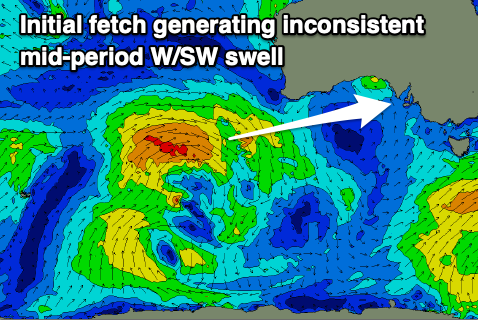
Firstly the W/SW swell will be generated by a healthy, slow moving low that's currently west-southwest of Western Australia. This will project a fetch of strong W/SW winds through our western swell window before dipping east-southeast and strengthening into a stronger low to the south of Western Australia Monday. This will produce gale to severe-gale W/NW winds, generating some stronger SW groundswell.
Both the mid-period W/SW swell and SW groundswell are due to build through Wednesday, with the Mid Coast reaching 1-2ft into the afternoon, with 4ft sets off Middleton, easing from a similar size on Thursday. Winds look favourable for both coasts Wednesday morning and locally offshore ahead of weak sea breezes, N'ly Thursday morning ahead of a trough and S/SW change into the afternoon/evening.
There looks to be plenty more swell to follow but a ridge of high pressure will bring S/SE-SE winds. More on this Monday. Have a great weekend!

