Fun surf into the weekend, cold and windy next week
South Australian Surf Forecast by Craig Brokensha (issued Wednesday March 1st)
Best Days: Tomorrow morning South Coast, South Coast Saturday and Sunday
Features of the Forecast (tl;dr)
- Temp low point in swell tomorrow ahead of a moderate sized S/SW swell building into the PM, peaking Fri, easing Sat
- Variable S winds tomorrow AM, freshening from the S/SE later AM
- Fresh, gusty E/SE-SE tending S/SE winds Fri
- Light NE winds Sat AM ahead of weak S/SE sea breezes
- Fun, S/SW groundswell for later Sat, easing Sun with light N winds, tending variable ahead of a mid-late PM W/SW-SW change
- Building semi-stormy swell on the Mid Coast Mon/Tue with strong W/SW winds
Recap
The Mid Coast continued to pick up fun 1.5ft waves through yesterday, with the rare bigger one as the tide pushed in. This morning we've got tiny 1ft+ sets with slightly lumpy conditions. The South Coast continued around 3-4ft yesterday, easing back from 3ft this morning but with fresh onshore winds. It's still been surfable for the keen and motivated.
This week and next (Mar 2 - 10)
A temporary low point in swell is due across the South Coast tomorrow morning ahead of some new mid-period S/SW swell building into the afternoon, peaking Friday.
The source of this moderate sized swell is back to back frontal systems firing up under the country the last few days. The first was weakest, while a secondary broader fetch of strong to sub-gale-force W/SW winds is now south of us, with the size due to build from later morning tomorrow.
We should see Middleton build to 3ft+ later tomorrow, peaking around 3-4ft on Friday before easing from 3ft on Saturday morning.
The Mid Coast isn't due to see much size but beginners will be happy with 1ft+ sets.

There's a window of lighter winds expected tomorrow across the South Coast, with a variable S'ly opening up options for the keen. Middleton looks to be 2ft to occasionally 3ft ahead of the new swell later morning. A freshening S/SE breeze is due from later morning so surf before then, while Friday will be poor under gusty E/SE-SE tending S/SE winds.
Saturday will see the mid-period S/SW energy starting to ease, but a reinforcing pulse of S/SW swell is due later in the day, slowing the easing trend through Sunday. The source will be a fetch of SW gales on the tail of the progression linked to tomorrow and Friday's swell, generated south-west of Tasmania tomorrow.
This should maintain 2-3ft sets into Sunday morning before easing through the day.

Conditions will improve for the South Coast on the weekend as winds shift NE Saturday morning before giving into weak S/SE sea breezes, light N'ly on Sunday, tending weak W/SW-SW mid-late afternoon as a trough pushes in from the west. This should provide plenty of opportunities for a fun surf all weekend.
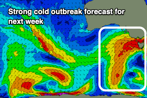
Later Sunday's change will be linked to the start of a strong, slow moving cold outbreak across the south-east of the country, bringing a ton of wind, swell and showery weather.
The early stages of this progression will have a bit of west in the winds, favouring protected spots down South while kicking up a semi-stormy swell across the Mid Coast, with winds shifting more S/SW from Wednesday. We'll have a closer this on Friday though.

