Plenty of swell but with south winds
South Australian Surf Forecast by Craig Brokensha (issued Monday February 27th)
Best Days: South Coast Saturday and Sunday mornings
Features of the Forecast (tl;dr)
- Moderate sized SW groundswell building Mon, holding Tue, easing Wed
- Moderate to fresh S/SE tending S winds tomorrow, stronger S Wed
- Light-mod S/SE-SE tending stronger S/SE winds Thu
- Moderate sized mid-period S/SW swell for Fri with E/SE-SE tending S/SE winds
- Slowly easing S/SW swell on the weekend with E/NE-NE winds each morning ahead of sea breezes
- Strengthening SW winds early next week with moderate sized pulses of swell
Recap
Tiny 1-1.5ft waves to kick off Saturday with early light winds on the Mid Coast, but the new W/SW swell kicked to a better 2ft through the afternoon with lighter winds. The swell eased back through 1-2ft yesterday with bumpy conditions again, while the South Coast was so/so with Saturday offering the cleanest conditions.
This morning we've got a good increase in SW groundswell but with less than ideal conditions continuing down South, clean on the Mid but tiny owing to the direction.

Good kick in size Saturday
This week and weekend (Feb 28- Mar 5)
Today's SW groundswell should peak into this afternoon with good 4ft sets off Middleton and 1-1.5ft across the Mid Coast, holding tomorrow thanks to a good reinforcing pulse. The size should then start easing on Wednesday from 3ft+ and 1ft to possibly 1.5ft respectively.
Unfortunately a high moving in today will see moderate to fresh S/SE winds develop through tomorrow, favouring the Mid Coast, while Wednesday will see stronger S'ly winds which isn't ideal at all.
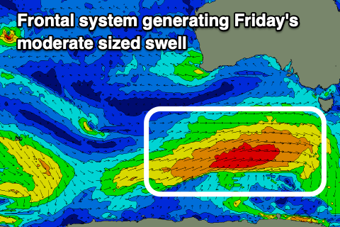
S'ly winds will persist into the end of the week as high pressure remains near stubborn to our west. At the same time a healthy polar frontal progression is set to generate another moderate sized pulse of mid-period S/SW swell for later week, but direction wise, the Mid Coast will mostly miss out.

An initial polar front to the south of Western Australia today will be relatively weak, ahead of a broader, stronger fetch of strong to gale-force W/SW winds tomorrow evening and Wednesday.
This secondary system will generate the most size, with mid-period energy due to build late Thursday, peaking Friday to 3-4ft across Middleton and 1ft+ on the Mid Coast.
S/SE-SE breezes are due Thursday morning, freshening into the afternoon with Friday seeing E/SE-SE morning winds.
Into the weekend we'll hopefully see more favourable E/NE-NE winds develop across the South Coast, creating cleaner conditions as the mid-period S/SW swell starts to ease from the 3ft range. Similar winds are likely on Sunday as the swell continues to ease from 2ft to possibly 3ft. The easing trend will be slowed thanks to the polar frontal progression stalling south-west of Tasmania later week.
Moving into next week, further pulses of mid-period S/SW swell are due Monday through Wednesday, but a weak frontal progression will push up and into us, providing some additional windswell but also bringing fresh to strong SW winds. There might be a few windows of W/NW winds around Victor in the mornings but we'll have to have a closer look at this on Wednesday.

