Average period with onshore winds spoiling the peak in swell energy
South Australian Surf Forecast by Craig Brokensha (issued Friday February 24th)
Best Days: Tomorrow morning for the keen protected spots down South (small), Mid Coast Sunday morning, Thursday morning down South
Features of the Forecast (tl;dr)
- Moderate sized, inconsistent W/SW swell building Sat, easing Sun
- Early W/NW winds down South, shifting SW and strengthening tomorrow
- Possible variable W winds tomorrow AM on the Mid, gusty SW into the PM, tending S/SE after dark
- Moderate S/SE tending S/SW winds Sun
- Moderate sized SW groundswell building Mon, holding Tue, easing Wed
- Moderate SE tending fresher S/SE winds Mon and Tue, strong S wed
- Possible variable winds Thu AM with a fun mid-period S/SW swell
Recap
Fading, weak S'ly swell energy yesterday with hot offshore winds down South, clean again this morning but about as small as it gets. The Mid Coast has been effectively flat.
A cooler change is due late afternoon, bringing gusty SW winds to both regions.

About as flat as it gets
This weekend and next week (Feb 25- Mar 3)
The weekend provides more swell potential, with an inconsistent, fun mid-period W/SW swell due to build through tomorrow before easing Sunday.
A small low that's formed in the Bight, bringing later this afternoon's cooler change should add some additional windswell to the mix later tomorrow and Sunday morning but mess with the local winds.
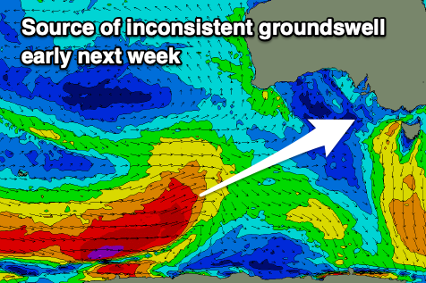
The stronger, mid-period energy was generated by a healthy low that formed around the Heard Island region earlier this week, weakening while projecting east-northeast towards Western Australia.
Size wise, the Mid Coast should build to an inconsistent 2ft on the sets tomorrow afternoon, easing from 1-2ft on Sunday. Middleton should build to 3ft tomorrow afternoon before easing from 2-3ft Sunday morning.
Locally, winds now look more favourable for the South Coast in the morning, light W/NW, while the Mid Coast looks dicey with light W'ly winds forecast. We may see a period of variable winds before fresher SW'ly breezes kick in and the swell builds. Winds aren't expected to really go S/SE until right on dark, so it's not looking the best.
Sunday will be much cleaner but with the fading swell under S/SE tending S/SW breeze.
Now, moving into next week, we've got some good SW groundswell mixed with mid-period energy, but a strong high slowly moving in from the west, behind the weak low moving through tomorrow will bring a poor run of winds.
A moderate SE'ly is due Monday morning before strengthening out of the S/SE, similar Tuesday, with strong S'ly winds holding into Wednesday.

This will spoil the whole swell event, and the Mid Coast, while being cleaner looks tiny owing to the origins of the swell.
That will be an elongated frontal progression that's developed between the Heard Island region and south of Western Australia. An elongated fetch of gales is being produced, with a few slightly stronger bursts in the mix.
It'll be inconsistent but Monday should build to 4ft across Middleton, hold Tuesday and then ease Wednesday from the 3ft+ range and with tiny 1ft to possibly 1.5ft sets on the Mid Coast.
We may see winds go more variable Thursday morning with mid-period surf to 3ft across Middleton, but it'll be brief with gusty S'ly winds due to return Friday and into next weekend. More on this Monday. Have a great weekend!


Comments
it'll be interesting how things pan out over the next few months seeing we are seemingly over the la nina weather patterns
Be very interesting... last 3 years have been shockers... guess it will take a while before returning to "normal "... and before the billions of dead carp start to clear...peeyoo
Think we'll get none and another crazy event happening for eastern and nw Coast Australia (wet wise). I'm sure it resembles the east coast getting hammered again and the Vic's getting none whole sa getting maybes
Wow, not often u see the day st stretch that small.
That heading pretty much sums up the last three years, give or take the odd day here and there.
Wanting a wave and curios i have just surfed Melbourne wave pool urbn surf for 12 one hour sessions . Monday 2 cruzers 1 progressive turns right . Tuesday 2 progressive turns left. Wednesday 3 progressive turns right. and 2 intermediate rights on Thursday and Friday last surf at 8pm . Next time i would only do 2 one hour surfs a day thats enough i am 67 year old . At least 10 to 14 waves in 1 hour and no hassling .Great people friendly staff and every one is here to have fun. The take off is the key and second section through the wave in intermediate . Next trip here i will build up to advanced and do a weeks surfing again . You must be surf fit enough to paddle hard for 1 hr. I really enjoyed the surf and the chlorine pool is fine . Recommend a surf trip here and now im off to The Great Ocean Road .