Strong swell for this afternoon with deteriorating conditions
South Australian Surf Forecast by Craig Brokensha (issued Monday February 20th)
Best Days: Mid Coast all day today, Mid Coast for the beginners tomorrow, South Coast Wednesday morning, Monday morning Mid Coast
Features of the Forecast (tl;dr)
- Mod-large SW groundswell building later this afternoon with gusty S/SE winds
- Rapidly easing moderate sized mid-period S/SW swell tomorrow with strong SE tending S/SE winds
- Building S/SE windswell tomorrow
- Easing mix of peaky swells Wed with fresh NE tending E/SE winds
- Fading surf Thu with mod-fresh N/NE tending E/NE winds, tiny Fri with stronger N/NE winds
- Building moderate sized W/SW swell Sat with strong SW winds, peaking Sun with fresh S/SW winds
- Easing surf Mon with morning SE winds
Recap
Light winds but small surf on Saturday across the South Coast, much better yesterday with a new moderate sized swell and good winds and conditions across both regions. The Mid Coast was a clean, fun 1-2ft with 3ft surf off Middleton, bumpy into the afternoon with sea breezes.
Today the swell has eased off temporarily down South but with clean conditions (now choppy) and sets to 2-3ft while the Mid Coast is hanging in at 1-2ft with the big morning high tide.
A moderate to large pulse of SW groundswell is due to arrive this afternoon, with the timing being a touch delayed along with a slight drop in size. This is thanks to the 'bombing low' linked to the swell forming a touch later and more east than forecast on Friday.
Regardless we should see sets pulsing to 6ft later today down South but with a gusty S/SE change, holding 1-2ft on the Mid Coast, and this will be the pick.

Great conditions down South this AM (now onshore with a change)

Glassy waves this AM
This week and weekend (Feb 21- 26)
This afternoon and evening's strong kick in SW groundswell will ease rapidly through tomorrow owing to the quick transition of the swell generating low to the east, away from our swell window.
We're looking at easing 1-1.5ft sets on the Mid Coast and 4ft waves off Middleton along with poor, strong SE winds that will shift S/SE through the day. These strong winds will also generate some junky S/SE windswell across the South Coast.
Wednesday should be better as winds shift NE thanks to a low forming in the Bight, squeezing the northern flank of a high pushing east behind the low and a peaky mix of easing S/SW and S/SE swells are due from 2ft to possibly 3ft as the Mid Coast fades to 0.5ft. Hit the South Coast magnets.
Expect the swell to bottom out into Thursday and Friday as the heat builds under fresh NE tending lighter E/NE winds on the former and strengthening N/NE winds on the later.

Unfortunately the weekend looks poor with a trough moving in Friday evening due to bring strong SW winds on Saturday that look to persist out of the S/SW on Sunday.
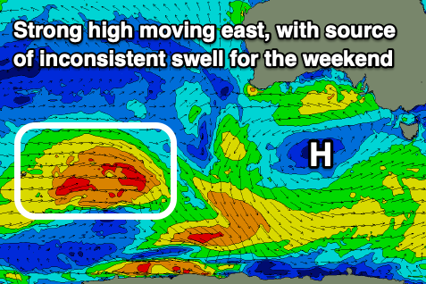
This will spoil a fun, moderate sized mid-period W/SW swell that's expected into Saturday afternoon and Sunday morning, generated by a healthy polar low that's currently in the Heard Island region.
A fetch of sub-gale-force W/NW-W/SW winds will project east-northeast, weakening while pushing up towards Western Australia. This will generate 1-2ft surf for the Mid Coast and 2-3ft waves for Middleton, but the remnants of the front looks to spawn a low in the Bight, bringing the onshore winds for the weekend and some additional W/SW swell.
2ft sets are due on the Mid Sunday but with those average winds, cleaner and easing Monday as winds shift SE.
Longer term there's nothing too significant on the cards so make the most of today's waves.

