Plenty of swell with a large upgrade for early next week
South Australian Surf Forecast by Craig Brokensha (issued Wednesday February 15th)
Best Days: South Coast tomorrow, South Coast Saturday morning, both coasts Sunday morning, Mid Coast Tuesday, South Coast Wednesday
Features of the Forecast (tl;dr)
- Reinforcing, inconsistent W/SW groundswell Wed PM, peaking Thu, with morning N/NE winds, tending N/NW and then variable ahead of a late SW change
- Easing surf Fri with freshening SW tending S/SW winds, likely W/NW early around Victor
- Small, inconsistent mid-period W/SW swell building Sat PM with a moderate sized SW swell for Sun
- Light S winds Sat, possibly variable in the AM, with N/NE winds down South Sun AM, E/NE on the Mid
- Easing surf Mon with E/NE tending SE winds
- Large SW groundswell for Tue with gusty E winds, easing Wed with fresh NE morning winds
Recap
Peaky, fun waves to 2-3ft across the South Coast yesterday morning and 1-1.5ft on the Mid Coast with the rare bigger one. Both coasts were best in the morning ahead of sea breezes.
This morning we've seen a temporary low point in swell with clean conditions across the South Coast, great on the magnets and tiny 1ft+ waves on the Mid.

Decent peelers yesterday

Fun waves this AM
This week and next (Feb 16 - 24)
A new, inconsistent SW groundswell is due to arrive this afternoon, peaking tomorrow morning, generated by a strong but distant polar low that fired up to west of the Heard Island region.
This swell arrived across Western Australia yesterday afternoon and is still solid this morning with it due to build later this afternoon, peaking tomorrow to an inconsistent 2-3ft across Middleton. The Mid Coast should see very infrequent 1-1.5ft sets and winds will favour the South Coast, N/NE through the morning, shifting N/NW early afternoon, possibly variable before a trough brings a SW change into the early evening.
Friday looks dicey as a trough brings a freshening SW tending S/SW breeze, with lighter W/NW winds a chance at dawn around Victor. A reinforcing mid-period SW swell should maintain 2-3ft sets across Middleton before easing into the afternoon.
A temporary low point is due on Saturday with light, possibly variable S'ly winds, creating decent conditions for the keen with 2ft sets across Middleton.
Later in the day some new mid-period SW swell is due, ahead of a stronger increase Sunday.
This will be generated by a flurry of frontal activity south of Western Australia today and tomorrow.
An initial front today will create an active sea state for the secondary system with stronger, sub-gale-force W/SW winds moving in tomorrow afternoon.

The swell might be seen late Saturday but a peak is due Sunday with good 3ft+ sets across Middleton, 1-2ft on the Mid Coast working the tides.
Winds will favour both coasts Sunday morning with offshore N/NE winds down South, E/NE on the Mid Coast ahead of weak sea breezes.
Conditions on Monday look a little funkier and E/NE across the South Coast with easing 2-3ft sets across Middleton, 1-1.5ft on the Mid Coast.
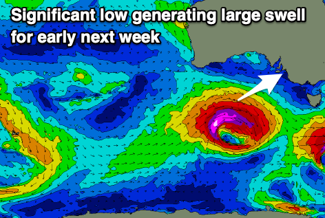
This swell has popped up on the charts with a significant low due to develop south of the country on Sunday, generating a fetch of severe-gale to storm-force W/SW winds while tracking quickly through our south-western swell window.
A large, significant SW groundswell is expected from this source, with it possibly showing on dark Monday but peaking Tuesday to 6-8ft across Middleton and 1-2ft on the Mid Coast.
Winds on Tuesday are a little in the air thanks to a deepening low to our west, with gusty E'ly winds likely but we'll have a closer look at this Friday. Better NE winds are likely when the swell eases Wednesday but again we'll confirm Friday.

