Fun South Coast waves from tomorrow
South Australian Surf Forecast by Craig Brokensha (issued Monday February 13th)
Best Days: South Coast tomorrow morning but more so Wednesday, Thursday and Friday mornings, Mid Coast for the keen tomorrow morning and Sunday, South Coast Monday morning
Features of the Forecast (tl;dr)
- Small, inconsistent mid-period W/SW swell building today, peaking Tue with mod-fresh E/NE winds tomorrow ahead of sea breezes, tending SE late on the Mid
- Reinforcing, inconsistent W/SW groundswell Wed PM, peaking Thu AM, with morning N/NE winds ahead of SE sea breezes mid-PM both days (fresher Thu and tending N/NW into the early PM)
- Easing surf Fri with early N winds, tending S late AM and strengthening
- Small, inconsistent mid-period W/SW swell building Sat PM with S/SW-SW winds, peaking Sun with S/SE tending S/SW winds
Recap
Not much in the way of surf for the weekend with a low point in swell across the South Coast Saturday morning with W/NW winds, and a junky windswell building on the Mid Coast but to no major size, fading yesterday.
Today has started tiny on the Mid Coast but some new W/SW swell should reach 1-1.5ft into the late afternoon/evening as sea breezes shift back S/SE late.

New lines of tiny swell
This week and weekend (Feb 14 - 19)
Looking at the coming week and the Mid Coast will be mostly a tease size wise, while the South Coast will be on the smaller side but clean up from tomorrow, best mid-late week as winds go more north.
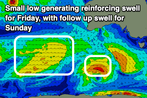
An inconsistent, small mid-period W/SW swell that's due to build into this afternoon should hold 1-1.5ft across the Mid Coast tomorrow, helped by a reinforcing pulse of inconsistent swell that was generated by a distant but weak polar low projecting up from the Heard Island region late last week.
There's the chance for the odd 2ft set on the favourable parts of the tide tomorrow afternoon, while the South Coast should come in around 2ft+.
Winds will be tend E/NE through tomorrow morning, even possibly NE at times down South before sea breezes kick in early afternoon and only swing back SE on dark across the Mid Coast.
Come Wednesday, the swell looks to ease from 1-1.5ft on the Mid Coast, with 2ft waves off Middleton under a N/NE offshore. Sea breezes are due early-mid afternoon and into the late afternoon, some new, inconsistent SW groundswell is due.
This swell was generated by a stronger but more distant polar low that formed south-east of the Heard Island region. A good fetch of severe-gale W/SW winds were produced but the low weakened once east of the Heard Island region so it'll be very inconsistent.

A peak is due Thursday with inconsistent 2-3ft sets across Middleton and 1ft to occasionally 1.5ft sets on the Mid Coast as N/NE breeze again favours the South Coast. It'll be a little fresher and tend N/NW into the afternoon ahead of a weak SW change late afternoon.
Easing surf is expected on Friday morning and a trough will start to move in from the west but a window of N/NE winds are due through the morning before shifting S'ly late morning and strengthening into the afternoon. S/SW-SW winds in the wake of the trough and a further drop in swell Saturday will make it a lay day.
Moving into the weekend we've got some new, inconsistent mid-period W/SW swell on the cards, generated by a broad but weak front pushing up and under WA through the middle of the week.
It should build later Saturday but peak Sunday with inconsistent sets to 1-2ft on the favourable parts of the tide on the Mid Coast and we should see winds tend S/SE through the morning ahead of sea breezes.
Longer term some further pulses of mid-period SW swell are due into next week with a window of favourable winds Monday morning before another trough brings a S'ly change. More on this Wednesday.


Comments
The U turns cam is a bit blurry, for a while does swellnet know, and can it be cleaned, it’s the main one I use.