Average outlook in general
South Australian Surf Forecast by Craig Brokensha (issued Monday February 6th)
Best Days: Wednesday morning South Coast, Thursday morning South Coast
Features of the Forecast (tl;dr)
- Easing SW groundswell tomorrow, with a building mid-period S/SW swell for the PM, easing Wed and smaller Thu
- Small S/SE windswell in the mix until Fri
- Mod-fresh E/SE tending strong S/SE winds tomorrow
- Lighter E-E/NE winds on Wed AM, giving into gusty S/SE sea breezes
- Smaller, easing surf Thu with E/NE-NE tending S/SE winds
- Poor Fri with fresh E/SE-SE tending stronger S/SE, then S/SW winds
- Tiny W'ly swell possible for Fri and Sat
Recap
Friday's oversized S/SW swell peaked into the afternoon across the South Coast with a variety of novelty options opening up for the keen and savvy.
The swell and winds started to ease through the weekend but unfortunately onshore S/SW-SW winds persisted through Saturday down South with easing 4-6ft surf, tiny and back to 1-1.5ft on the Mid Coast. Much smaller than expected in the gulf with the swing in swell direction to the south making a big impact.
Yesterday morning was fun with variable winds across the South Coast and lumpy/bumpy waves for the keen. A new SW groundswell arrived into the afternoon but with fresher onshore winds, holding 3ft this morning but with unfavourable E/SE winds.
This week and weekend (Feb 7 - 12)
Following last week's strong cold outbreak and large stormy surf, the coming period is a return to small swells and winds from the south-eastern quadrant.
A high has moved in from the west and this will bring strengthening S/SE winds this afternoon, shifting E/SE tomorrow morning before reverting back to the S/SE into the afternoon.
Swell wise, the current inconsistent SW groundswell will ease, and some new, small mid-period S/SW swell is due to fill in through the afternoon, easing Wednesday.

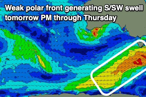
This is being generated by a weak, elongated polar front projecting up and across Tasmania this afternoon and evening.
Fetches of strong SW winds should generate 2-3ft of S/SW swell for tomorrow afternoon and Wednesday morning, then still 2ft Thursday morning but easing. There'll also be some junky S/SE windswell in the mix from the persistent afternoon/evening S/SE winds.
Winds on Wednesday may tend a little more E-E/NE ahead of S/SE sea breezes, with more variable E/NE-NE winds due on Thursday but with the small, easing swell.
A low point in swell is expected on Friday and with dicey E/SE-SE winds, strengthening from the S/SE, shifting S/SW into the evening as a new trough slides in from the west.
There may be a tiny W/SW swell generated by the trough but not above 1ft on the Mid Coast, fading Saturday from a similar size with what looks to be morning S/SE winds.
Unfortunately the longer term outlook isn't too special at all with weak mid-latitude fronts expected to generate small to tiny pulses of W/SW swell next week along with S/SE-SE winds. We'll have a closer look at this on Wednesday.


Comments
So happy I got great waves Thursday and Sunday down south; the surf report doesn’t look good going forward: Owe Danny Boy