Tricky weekend, lots of action next week
South Australian Surf Forecast by Craig Brokensha (issued Friday January 27th)
Best Days: This morning South Coast, keen surfers tomorrow morning South Coast, Mid Coast Monday, Tuesday morning and Wednesday morning, South Coast Wednesday morning
Features of the Forecast (tl;dr)
- Fading mid-period SW swell tomorrow with pre-dawn SW winds, tending variable W/NW then fresh S/SW late AM
- Gusty S/SE winds Sun with a small mid-period W/SW swell arriving late, peaking Mon AM
- Stronger, mid-period SW swell building Mon with mod-fresh S/SE-SE winds
- Swell holding Tue with mod S/SE-SE tending strong SW winds
- Inconsistent SW groundswell for Tue PM, easing Wed with variable tending SW winds Wed
- Further sizey swell later next week with winds unsure
Recap
An average start to conditions across the South Coast yesterday morning but winds eased off through the day and the surf cleaned up, offering fun waves for the afternoon paddle.
This morning conditions are cleaner and peaky with a mid-period SW swell to 2-3ft across Middleton under an offshore breeze. The Mid Coast is offering tiny 1ft+ waves for beginners.

Clean, peaky conditions this AM
This weekend and next week (Jan 28 – Feb 3)
Make the most of the clean conditions this morning, as winds will swing ESE early afternoon as the swell starts to ease.
Tomorrow is a tricky one. Right before dawn, a trough is due to bring a SW change to the Victor region but this will weaken and result in winds tending variable W/NW through the morning before a more pronounced change moves in late morning. Therefore expect some funky conditions but surfable waves tomorrow morning, but easing back from 1-2ft across Middleton. Not ideal and worth chasing too hard.
Into Sunday a high will fill in from the west and this will see winds strengthening from the S/SE.
Swell wise the South Coast will be small, but on the Mid Coast we should see a fun new pulse of mid-period W/SW swell building through the late afternoon, possibly reaching 1-1.5ft by dark (full) but Monday is a better chance to see a wave.
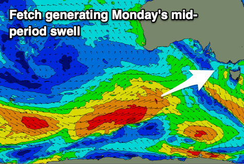
This swell is being generated by a weak fetch of W/SW winds projecting under Western Australia today and should provide inconsistent 1ft to occasionally 2ft sets on Monday.

There'll be some stronger mid-period SW swell filling in Monday afternoon which will help bolster this swell, generated by a strong polar low come frontal progression that's currently firing up behind the weak front.
Initially a fetch severe-gale W/SW winds were generated around Heard Island, with the low now racing ahead of the swell produced by this fetch, generating additional strong to gale-force W/SW winds while projecting east-northeast under WA tomorrow.
The bulk of the swell is now due into Monday afternoon and Tuesday morning with good 2ft surf due on the Mid Coast with 4ft waves across Middleton.

The groundswell should maintain the surf to 4ft+ down South while the Mid looks to become less inconsistent, easing from 1-2ft Wednesday morning.
Unfortunately winds will be poor for the South Coast but favourable for the Mid with moderate to fresh S/SE-SE winds Monday and S/SE-SE tending strong SW winds on Tuesday. Wednesday morning may see a more variable breeze develop on the South Coast but we'll confirm this on Monday.
Following the activity early next week, a trailing and broad polar frontal progression moving under the country should generate some moderate sized reinforcing SW swell for Thursday/Friday. A polar front may deepen and push up into us, bringing larger surf for the South Coast but with poor local winds. The models diverge regarding this so check back here on Monday for the latest. Have a great weekend!

