Very poor outlook
South Australian Surf Forecast by Craig Brokensha (issued Wednesday January 18th)
Best Days: Beginners and bigger boards on the Mid Coast later today and tomorrow
Features of the Forecast (tl;dr)
- Moderate sized, mid-period SW for later today, easing tomorrow with strong SE tending S/SE winds
- Easing mix of swells for Fri with moderate E/SE-SE tending fresh S/SE winds
- Building S/SW groundswell Sat with fresh S/SE winds, strengthening through the day
- Easing mix of swells Sun with moderate S/SE winds, strengthening through the day
- Easing S/SE windswell Mon with variable tending S/SE winds
- Strengthening S winds Tue with a weak S windswell
Recap
Tiny clean leftovers across the Mid Coast yesterday following Monday's good swell, while the South Coast was great through the early/mid morning ahead of a strong onshore change later morning, a little earlier than expected.
The trough linked to this change is now pushing east leaving poor, strong S'ly winds across the South Coast today and tiny, peaky waves on the Mid Coast.
Later today a new pulse of mid-period SW swell is expected, and this should kick to 1-1.5ft on the Mid Coast and 3ft+ down South as winds shift S/SE.
Note the increase on the Cape du Couedic wave bouy this morning isn't the new expected swell, but localised windswell. The period and direction tell the story..


Swell period bottoming out as wave heights increase, indicating windswell
This week and next (Jan 19 - 27)
Following yesterday's cool change, we're now set for a run of poor winds and conditions across the South Coast thanks to a strong high moving into the Bight, stalling there until later in the weekend.
This will see poor, strong SE tending S/SE winds blowing through tomorrow, easing a touch Friday morning and shifting E/SE-SE but not enough to clean up the South Coast.

Later today's mid-period SW swell should hold in around a similar size tomorrow morning, before easing with some localised S/SE windswell down South. Easing 3ft+ waves are due across Middleton with infrequent 1-1.5ft sets on the Mid Coast, best for beginners.
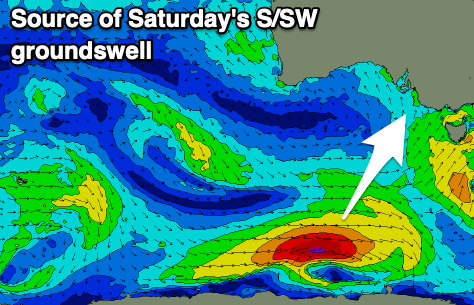
Fresh S/SE winds will develop through Saturday, strengthening through the day along with a new, building S/SW groundswell on the South Coast.
The swell is being generated today by a strengthening polar low to the south of Western Australia, producing a fetch of W/SW gales in our southern swell window.
Good 3ft sets are due to develop across Middleton by late morning but with those poor conditions, easing in size Sunday as winds back off a touch though remain moderate out of the S/SE.
Moving into next week, winds look to ease further and become more variable Monday morning but there'll be no decent swell of size or power left in the mix. Unfortunately another trough will bring a return to strengthening S'ly winds on Tuesday that should slowly swing anti-clockwise into the end of next week.
Swell wise there's nothing significant due as the Southern Ocean enters a quiet spell. All in all it's a poor forecast period.

