Deteriorating surf so make the most of the coming days
South Australian Surf Forecast by Craig Brokensha (issued Monday January 16th)
Best Days: Today, Mid Coast for the keen tomorrow, Wednesday and Thursday, South Coast tomorrow ahead of the change
Features of the Forecast (tl;dr)
- Easing mid-period W/SW and SW swells this afternoon, smaller tomorrow
- N/NE tending W/NW-NW winds ahead of a mid-late PM SW change tomorrow
- Small, inconsistent W/SW swell for later tomorrow and Wed, ahead of a stronger SW swell later Wed, and Thu AM
- Strong S/SE-S winds Wed, gusty S/SE on Thu
- Fresh SE tending strong S/SE winds Fri, Sat and Sun
- Moderate sized S/SE windswell later week through the weekend
Recap
Super fun waves on the South Coast magnets Saturday with great conditions and a small swell, poor yesterday as a trough brought strong onshore winds and a choppy, building windswell.
The Mid Coast saw tiny surf on Saturday, more wind affected yesterday but building to 2ft while today is the pick with better offshore winds and surf holding 2ft on the reefs and beaches. The South Coast is a bit cleaner this morning but all over the shop as winds are shifting cross-offshore along with 3ft+ of swell.

Pumping this AM (now onshore)
This week and weekend (Jan 17 - 22)

If you're looking to surf the South Coast this period, either get out there now before the sea breeze hits, or surf tomorrow morning.
Tomorrow, an offshore N/NE breeze is due to shift W/NW-NW into the early afternoon before a trough brings a strong SW change and we'll be looking at smaller, easing surf from 2ft+ across Middleton. The Mid Coast should be fun though back to 1-1.5ft, with a new pulse of mid-period W/SW swell due to arrive later, stopping the easing trend.
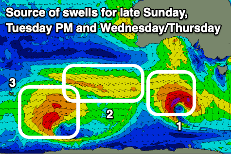
This swell and a reinforcing pulse of better mid-period SW swell due later Wednesday and Thursday morning were generated by a broad polar low developing to the east of the Heard Island region late last week.
The first for late tomorrow was generated by a weak fetch of strong W/NW winds, with the secondary stronger pulse but with more south in it being generated by W/SW winds around the core of the low.

Inconsistent 1-1.5ft sets are due on the Mid Coast tomorrow through Thursday, with strong S/SE-S winds on Wednesday, a touch weaker but still gusty at times and out of the S/SE on Thursday.
The South Coast will be a mess but with 3ft+ waves into later Wednesday from the mid-period SW swell, easing Thursday from a similar size and then smaller Friday.
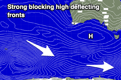
Unfortunately a strong high will move into the Bight later week and sit there into the weekend, with persistent SE tending strong S/SE winds and no real significant groundswells. Local S/SE windswell will dominate the period, easing into early next week as winds slowly abate. Therefore with the poor outlook make the most of the current swell and waves.

