Easing surf as winds slowly improve
South Australian Surf Forecast by Craig Brokensha (issued Wednesday January 11th)
Best Days: This morning Mid Coast and South Coast, Friday morning South Coast, later Sunday Mid Coast and Monday morning, South Coast Monday and Tuesday mornings
Features of the Forecast (tl;dr)
- Slow easing trend in W/SW-SW swell Thu/Fri, bottoming out Sat
- Light to moderate SE-E/SE tending S/SE winds tomorrow, light N/NE tending SE Fri
- Light N/NE winds ahead of a strong PM SW change Sat
- Moderate sized S windswell for Sun down South with strong S/SE winds
- Small mid-period W/SW swell kicking late Sun, easing Mon
- Moderate sized mid-period S/SW swell Mon with E/NE-NE tending SE winds
- Easing swell Tue with N/NE winds ahead of a SW change
Recap
Super fun waves across the Mid Coast continued yesterday with a peak in W/SW swell energy and 2ft waves for the most part, mixed in with the rare bigger one. The South Coast offered plenty of size but conditions were poor yesterday morning, improving a touch through the afternoon.
This morning the swell is back to a slower 1-2ft wave on the Mid Coast while the South Coast is a little cleaner with sets still reaching 3ft. Conditions will deteriorate into the afternoon across both coasts with sea breezes.

Fun surf yesterday PM
This week and next (Jan 12 - 20)
We've got a slow easing trend in size over the coming days across both regions as winds slowly improve for the South Coast.
The Mid Coast will become tiny and only be suited to beginners tomorrow, with the South Coast still seeing 2-3ft waves off Middleton but with an unfavourable light to moderate E/SE-SE breeze.
Friday morning looks the pick with a light N/NE offshore breeze but smaller, easing swell from 2ft across Middleton. The magnets will be the pick.
Saturday morning will be clean again with a N/NE offshore but the swell will be tiny and fading from 1-1.5ft. A trough will bring a strong SW change early afternoon, with winds due to quickly revert back to the S/SE on Sunday but remain strong with a localised increase in windswell.
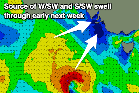
Later in the day across the Mid Coast some new mid-period W/SW swell energy should be seen, generated by a mid-latitude front pushing up and under Western Australia Friday.

This front will dip south-east while strengthening, generating an additional mid-period S/SW swell for the South Coast on Monday, but coming back to the Mid Coast, we should see a late spike to 1-2ft on Sunday with Monday easing from a similar size.
Middleton should offer 3ft waves with the windswell Sunday and mid-period swell Monday as winds improve on the latter, shifting E/NE-NE through the morning. There'll be a lot of lump and randomness down South Monday but it'll be worth a paddle.
Tuesday morning looks cleaner down South ahead of another trough and SW change through the afternoon, along with some smaller surf.
Longer term some fun SW groundswell is due Wednesday/Thursday but with S/SE-SE winds. More on this Friday.

