Average, slow outlook, better next week
South Australian Surf Forecast by Craig Brokensha (issued Monday January 2nd)
Best Days: Mid Coast for the keen and patient later today and tomorrow, South Coast for the keen Saturday and Sunday mornings, Mid Coast next week
Features of the Forecast (tl;dr)
- Inconsistent mid-period W/SW swell tomorrow, easing Wed with strong S/SE tending S-S/SW then S/SE winds tomorrow, strong S/SE Wed
- Easing surf Thu with mod-fresh SE tending strong S/SE winds
- Smaller Fri with moderate E/SE tending gusty S/SE winds
- Small, peaky S/SE windswell for the weekend with mod-fresh NE tending SE winds
- Good W/SW groundswell for next Tue/Wed with S/SE winds
Recap
Tiny waves for beginners on the Mid Coast Saturday, lumpy and small across the South Coast, better yesterday morning with a lift in inconsistent SW groundswell and slightly cleaner conditions.
Today is poor with a strong S/SW change moving through in the wake of a trough along with a new, building mid-period SW swell. The Mid Coast is semi-clean and to 1-1.5ft but we should see a bit more consistency and size to the swell through the afternoon. Sea breezes will kick in, shifting S/SE late.
This week and weekend (Jan 3 - 8)
Now that the trough has moved in across the state we'll see winds remain poor for the South Coast all week, improving slightly on the weekend.
A strong high is moving into the Bight and the trough will form into a weak low east of Tasmania, squeezing the eastern flank of the high. This will direct strong S/SE-S winds into us, weakest through the mornings and strongest into the afternoons and evenings.
Swell wise, there's some mid-period SW swell due to hold through tomorrow, Wednesday and then ease Thursday, mixed in with S'ly windswell to a choppy 3ft or so.
On the Mid Coast, we should see some fun though infrequent W/SW swell energy maintaining 1-2ft sets tomorrow, easing Wednesday. This will be the pick though wind affected at times. The tides will be unfavourable with overnight big pushes in and more dodge through the day.
For the South Coast, winds should ease and tend more E/SE through the morning Friday though it'll be mostly junky windswell and no shape or power.

Moving into the weekend, we'll see winds shift NE down South both Saturday and Sunday as the high slips south-east ahead of another trough.
This will create cleaner, peaky conditions across the South Coast but there'll be no new swell in the water unfortunately with weak peaky 2ft sets, with the rare bigger one on the exposed beaches.
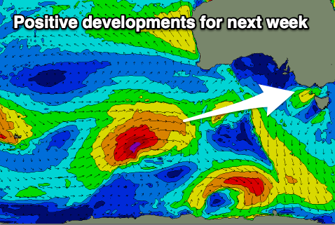
The longer term outlook is more promising next week with a series of strengthening storms due to fire up to the south-west of Western Australia, pushing up towards the Bight generating some good W/SW swell for early-mid next week. Winds look to be favourable for the Mid Coast but more on this Wednesday.

