Fun options for the South Coast
South Australian Surf Forecast by Craig Brokensha (issued Monday October 17th)
Best Days: This morning South Coast, later this arvo/evening for the keen Mid Coast, tomorrow morning South Coast, Friday morning South Coast, Saturday morning South Coast (check back Wednesday for confirmation on timing of trough), Mid Coast Monday
Features of the Forecast (tl;dr)
- Easing surf tomorrow with fresh N/NE tending E winds
- Smaller Wed with E/NE tending strong S/SE winds
- Small S/SW swell Thu with gusty S/SE winds
- Better, moderate sized S/SW swell late Thu, peaking Fri AM and then easing with variable tending SW winds (E/SE Mid and W/NW down South)
- Easing S/SW swell Sat with early variable winds ahead of a S change
- Poor, strong S/SE winds Sun and Mon with an inconsistent W/SW swell
Recap
The surf dropped back to a fun 1-2ft on the Mid Coast Saturday morning with a light onshore breeze through the morning, clean down South but tiny. Sunday was clean but back to 1ft on the Mid Coast while a new pulse of mid-period SW swell offered better 2-3ft sets with great conditions ahead of a late morning sea breeze.
Today our stronger mix of S/SW and SW groundswell are offering better 3-4ft surf across Middleton today with great conditions, 1-1.5ft on the Mid Coast. Sea breezes will kick in across both coasts this afternoon, so make the most of this morning.

Good sized mix of S/SW and SW swell this morning
This week and weekend (Oct 18 - 23)
Looking at the coming days and we'll see our mix of S/SW and SW groundswells from this morning starting to ease this afternoon, further tomorrow and bottoming out Wednesday.
Conditions will be good for the South Coast with a N/NE offshore tomorrow morning, freshening from the E into the afternoon along with easing sets from 3ft at Day St and Goolwa (2-3ft for the most part). The Mid will be tiny and a little wind affected through the morning.
Unfortunately Wednesday looks to be a lay day as the swell fades and a trough brings less favourable winds. An E/NE breeze is likely down South in the morning but with 1-2ft leftovers, tiny to flat on the Mid Coast. Conditions will deteriorate from late morning as winds strengthen and tend S/SE.
This trough will spoil conditions on Thursday with a gusty S/SE'ly due to persist, while Friday will hopefully see more variable winds, tending E/SE on the Mid and W/NW around Victor Harbor in the morning.
This improvement in winds will also coincide with a moderate sized lift in mid-period S/SW swell energy.
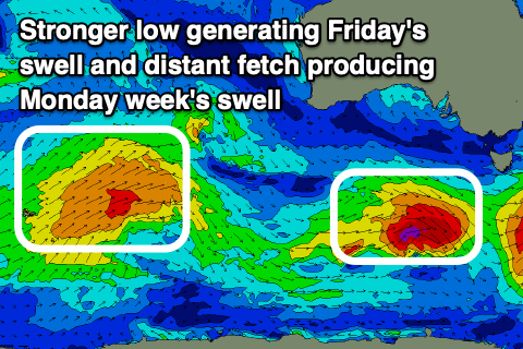
The source will be a strengthening low, south of us on Tuesday evening and Wednesday, the second behind a small, late forming low this evening. This first low may generate 2ft+ of S/SW swell for the South Coast Thursday, but with those poor winds.
 The secondary low will be stronger, with a fetch of gale-force W/NW winds generated a little off axis to our swell window, with a possible small core of severe-gale winds.
We should see this generate a great S/SW swell for late Thursday, peaking Friday morning, coming in at 3ft+ across Middleton and with those slightly better winds.
The Mid won't see any real size owing to the southerly angle of the incoming energy.
Easing surf is expected into Friday afternoon, dropping from 2-3ft across Middleton on Saturday and with more favourable N winds ahead of a S/SW change with a trough.
Now the timing and strength of this trough is still undecided and we may see the change move in before dawn Saturday, but check back here Wednesday for a clearer idea on this.
A strong high moving in behind the trough looks to spoil conditions into Sunday and Monday with strong S/SE breeze, but we'll have another look at this on Wednesday.
This will spoil an inconsistent W/SW swell due later Sunday and Monday down South, with cleaner conditions on the Mid and possible 1-2ft sets. See you back here Wednesday.


Comments
Hi Craig, one of the lads tried to clean the knights cam to get that blurry spot off and noticed there’s a little crack on the screen. Most the lads like to watch their replays so it’s hot topic at the moment haha. Any chance of getting it replaced?