Fun, clean mornings for the South Coast
South Australian Surf Forecast by Craig Brokensha (issued Friday September 30th)
Best Days: This afternoon Mid Coast, very morning over the coming period down South until Tuesday/Wednesday, Thursday morning down South
Features of the Forecast (tl;dr)
- Easing surf tomorrow with early N-N/NE tending E/NE winds down South ahead of S/SE sea breezes, E/NE on the Mid in the AM
- Late increase in SW groundswell tomorrow, peaking Sun with light-moderate N/NE tending fresh S/SE winds
- Easing surf Mon and Tue with NE tending E/NE winds Mon, fresher E/NE Tue
- New small mid-period SW swell Wed with gusty E/NE winds, easing Thu with N/NW winds
Recap
Conditions have been on the slightly better side of expectations down South the last two mornings with light E/NE breezes and lumpy 2-3ft surf across Middleton. The Mid Coast was a tiny 1ft yesterday morning but the reinforcing pulse of mid-period swell and incoming tide pushed sets to an easy 2ft into yesterday afternoon with favourable winds.
This morning we've got a slight drop in energy back to 1-1.5ft but we should see sets kicking again to 2ft into the afternoon with the help of the tide.

Great size yesterday PM
This weekend and next week (Oct 1 - 7)
 Winds will continue to improve over the coming weekend across the South Coast with a low point in swell due tomorrow morning ahead of a new, inconsistent SW groundswell into the afternoon but more so Sunday.
Conditions should be much cleaner with a variable offshore N-N/NE breeze down South at dawn, though quickly shifting E/NE mid-late morning ahead of sea breezes. So go the early. Sets to 2ft are expected across Middleton. The Mid should be clean with E/NE winds but the current swell will back off to a tiny 1ft on the sets.
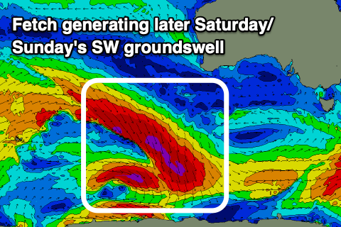
The new SW groundswell due into the late afternoon and Sunday was generated by an off-axis but healthy fetch of severe-gale NW winds tracking towards the polar shelf this week, with some good energy due to spread up radially off this source.
 It'll be inconsistent but sets to 3ft are due across Middleton with tiny waves on the Mid Coast to 0.5-1ft and conditions look good again, with a light N/NE offshore ahead of afternoon sea breezes.
This swell should start to ease later Sunday and become smaller Monday, easing from 2ft+ across Middleton under a NE offshore.
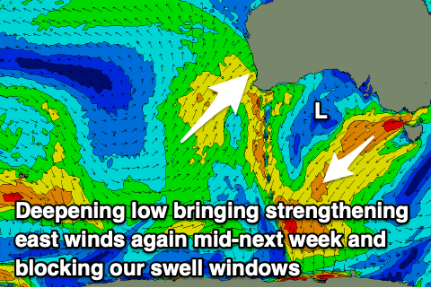
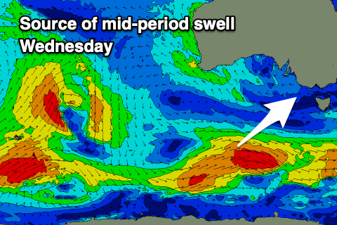
Now, moving into Tuesday and Wednesday, a deepening mid-latitude low in the Bight will bring strengthening E/NE winds along with smaller, background levels of mid-period swell. This isn't ideal with Tuesday only looking to be 2ft max across Middleton/Goolwa, while a small pulse of mid-period SW swell from weak but persistent polar frontal activity under the country on the weekend should boost wave heights to 2-3ft Wednesday.
 The low will start moving east later week, swinging winds N/NW on Thursday but with fading surf that will reach a low point Friday.
Longer term, the backside of the mid-latitude low looks to bring some W/SW swell into next weekend but with westerly winds. We'll have a closer look at this on Monday.
Have a great weekend!

