Fun options across both regions this period
South Australian Surf Forecast by Craig Brokensha (issued Monday September 19th)
Best Days: This afternoon both coasts, selected spots South Coast tomorrow, beginners on the Mid, Thursday both coasts, early Friday morning South Coast, Mid Coast Saturday, South Coast Sunday
Features of the Forecast (tl;dr)
- Inconsistent W/SW groundswell building later today, easing tomorrow with strong but easing NE tending N/NE winds down South, N/NE tending E/NE on the Mid
- Reinforcing W/SW swell Wed with strong S/SW tending SW winds
- Moderate sized + W/SW swell for Thu, with a secondary stronger groundswell for Fri PM and Sat AM
- Variable winds ahead of sea breezes Thu (offshore Mid, light S down South), fresh W/NW tending strong S/SW Fri (NE dawn Mid), E/SE Sat AM
- Easing surf Sun with N/NE tending SE winds
Recap
Stormy 3-4ft waves on Saturday across the Mid Coast, easing a touch into yesterday with choppy 2-3ft waves. The South Coast was best in protected spots on Saturday but not seeing much of the size at all, great yesterday with 3-4ft surf and fun waves in protected spots ahead of a late SW change.
Today the size has eased a little back to 2-3ft across Middleton but with better winds for more exposed breaks. The Mid was also cleaner with a variable morning breeze which has freshened a little out of the N'th along with fun 2ft sets. Variable winds are due into the afternoon, creating cleaning conditions and fun waves into the evening.
Our new, inconsistent, W/SW groundswell due this afternoon is pinging on the Cape du Couedic wave buoy and should maintain good 3ft sets across Middleton with 1-2ft sets continuing on the Mid.

Great conditions early this AM
This week and weekend (Sep 20 - 25)
Our new, long-period W/SW groundswell for this afternoon and tomorrow morning came in well across Western Australia yesterday morning, with it being generated by a strong but poorly structured low late last week.
It'll be inconsistent but sets to 3ft are due across Middleton this afternoon and tomorrow morning, 1-1.5ft on the Mid Coast tomorrow.
A mid-latitude low approaching from the west will bring strong and tricky NE winds tomorrow morning, easing and tending lighter N/NE into the afternoon, with the Mid seeing winds tend N/NE before easing and going more offshore into the afternoon.
Wednesday looks to be a lay day as the low moves across us, bringing strong S/SW tending SW winds to both regions along with some reinforcing mid-period W/SW energy to 1-2ft on the Mid Coast and 2-3ft down South.
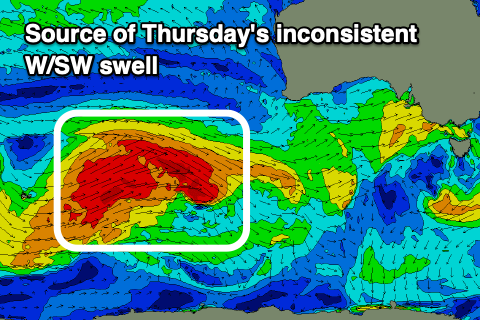
From Thursday we're due to see our inconsistent but good pulses of W/SW groundswell filling in, generated by a multi-threaded polar frontal progression that firing up across the Heard Island region and to the south-west of Western Australia over the weekend.
 An initial swell for early Thursday was generated through Saturday and Sunday, while a reinforcing pulse due to arrive just after was generated by W'ly gales, to the south-west of Western Australia last night.
The swells should offer good sized surf across both regions, coming in at an inconsistent 3-4ft across Middleton Thursday, with 2ft sets on the favourable parts of the tide across the Mid Coast.
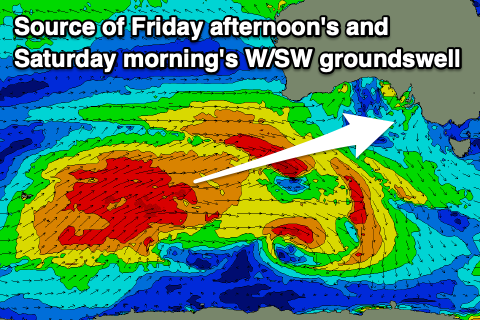
Similar sized waves are due Friday morning, but into the afternoon our stronger pulse of groundswell is due, generated by a fetch of W/SW-SW gales east of the Heard Island region this evening and tomorrow morning. The front will weaken while projecting north-east towards the Bight, with some smaller mid-period energy being in the mid Saturday.
Middleton should build 3-5ft Friday afternoon and ease from a similar size Saturday morning with 2ft+ sets on the Mid Coast.
 Variable winds are due into Thursday morning following Wednesday's onshore breezes, cleanest on the Mid, with a lingering S'ly breeze possible for the first hour or two of light down South.
Another trough moving in from the west on Friday will see an early window of fresh W/NW winds ahead of a strong S/SW change mid-morning down South. The Mid may see a brief period of light NE winds but Saturday looks the pick as the trough clears and wind shift back to the E/SE.
The South Coast will be OK but best Sunday with easing surf and a NE offshore.
Longer term there's another run of mid-latitude fronts/lows into the final week of September, but more on this Wednesday.

