Large westerly swell inbound, cleanest down South
South Australian Surf Forecast by Craig Brokensha (issued Wednesday September 14th)
Best Days: South Coast Friday, Saturday morning and Sunday, South Coast Tuesday
Features of the Forecast (tl;dr)
- Low point in swell early tomorrow AM ahead of a strong pulse of W/SW groundswell later in the day
- Strong N-N/NW tending NW winds tomorrow
- Large W/SW groundswell and stormy windswell for Fri and Sat with strong NW tending W/NW winds Fri, strong W/NW tending W/SW early PM Sat
- Easing W/SW swell Sun with fresh W/NW tending NW winds
- Smaller Mon with fresh W/NW tending weaker SW winds
- Inconsistent SW groundswell Tue with N/NE winds
- Moderate sized + W/SW groundswell later next week with variable winds Thu, possible S/SW Fri
Recap
Great surf across the South Coast yesterday with clean conditions and solid easing sets from 4-5ft across Middleton, holding 4ft into the afternoon as winds remained favourable out of the NE. The Mid Coast was back to 1-1.5ft, best on the afternoon incoming tide but a little wind affected.
Today the swell is fading with stronger NE winds, limiting options down South, choppy and near flat on the Mid Coast.
This week and weekend (Sep 15 - 18)
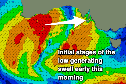
 The strengthening in winds seen through today are linked to a deep, slow moving mid-latitude low moving slowly in from the west. Check out Satview for a great overview of the storm and embedded fronts.
This low formed just south of Western Australia and we're seeing a fetch of strong to gale-force W/SW winds being projected into the Bight today as the low moves slowly east.
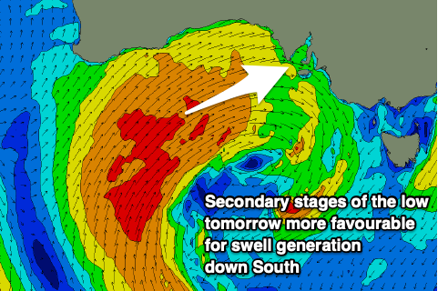
The slow moving nature of the low will see bursts of gales acting on top of an already energised sea state, producing a large, prolonged W/SW groundswell event that will build Thursday afternoon but be strongest Friday through Sunday.
During this whole period the low will continue to project favourable winds through our swell window, becoming weaker Friday evening and Saturday as it moves across us.
 Looking at the sizes and the Mid Coast will start from a tiny base tomorrow but reach 2-3ft by dark but with strengthening N-N/NW tending NW winds. The South Coast will be clean but tiny with 1-2ft sets due across Middleton later in the day.
Come Friday strengthening NW tending W/NW winds will add some additional windswell to the mix on the Mid Coast with stormy 4ft waves due to develop through the day, holding Saturday with strong W/NW tending W/SW winds.
The South Coast will see a lot less size owing to the westerly angle of the incoming energy, likely mostly 3ft on Friday morning across Middleton, building further later to the 4ft range with a peak in size Saturday to 3-5ft.
Protected spots will be best Friday and Saturday morning ahead of the afternoon W/SW change.
Moving into Sunday and we should see the swell starting to ease across both regions as the low starts clearing to the east, dropping from 3ft across the Mid Coast and 4ft across Middleton.
Winds will be great for the South Coast with improving conditions expected through the day under a fresh W/NW tending NW breeze. Unfortunately the Mid looks to remain bumpy and choppy.
 Come Monday, smaller surf is due and with fresh W/NW tending weaker SW winds as a final front clips us and then clears to the east.
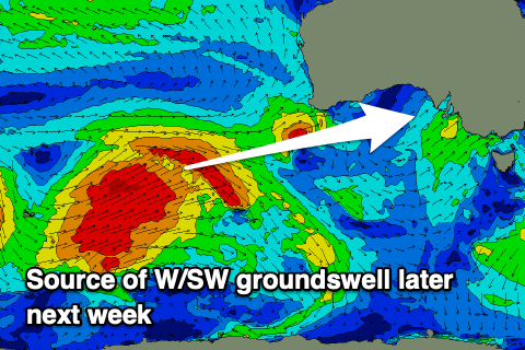
Now, looking at the rest of next week, and a small, inconsistent long-period SW groundswell is due on Tuesday generated by a strong but unconsolidated polar low to the south-west of Western Australia. Size off this only looks to be 2-3ft across Middleton with favourable NE winds ahead of an evening trough and S/SW change into Wednesday.
Later in the week some better and bigger W/SW groundswell is due across the state with what looks to be generally light winds Thursday. More on this Friday though.

