West followed by south
South Australian Surf Forecast by Craig Brokensha (issued Wednesday August 10th)
Best Days: Mid Coast early Friday, South Coast possibly Sunday and Monday mornings
Features of the Forecast (tl;dr)
- Moderate sized W'ly swell for tomorrow with gusty N/NW winds, tending N late in the day
- Reinforcing W'ly swell Fri with strengthening SW winds (likely variable early on the Mid Coast)
- Easing W swell Sat with mod-fresh S/SW winds
- Mod-large S'ly swell Sat, easing Sun with W/SW winds (possibly W/NW early down South)
- Easing surf Mon with W/SW winds (possibly W/NW early down South)
Recap
A tiny hint of swell on the Mid Coast yesterday morning to 0.5-1ft and with clean conditions, poor into the afternoon with an increasing N'ly wind. The South Coast was better with 2ft sets across Middleton, best in the morning.
Today there's a bit less swell out there with the reinforcing mid-period energy not showing too well and NE winds are favouring more exposed locations down South, tiny and wind affected on the Mid Coast.
This week and weekend (Aug 11 - 16)
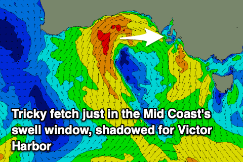
We've got some new W'ly swell due into the end of the week, generated by a strong mid-latitude low that formed south-west of Western Australia, generating an off axis fetch of strong to gale-force S/SW winds aimed mostly north.
The low has since weakened and is moving in through the Bight but will strengthen again, aiming an additional fetch of strong to gale-force W/SW winds just within the Mid Coast's swell window.
 Unfortunately all the activity will be too far north for the South Coast, blocked by Kangaroo Island again.
Inconsistent 1-2ft sets max are due across Day St to Goolwa tomorrow, easing from a similar size Friday morning.
The Mid Coast should kick to 2ft through tomorrow, holding 2ft on Friday owing to the additional fetch high in the Bight today.
Winds will be best for the South Coast and cross-shore for the Mid Coast tomorrow with fresh and gusty N/NW breezes, tending more N'ly later. Friday is funky as the low moves in and across us, bringing strengthening SW winds that may be light and variable at dawn. The Mid Coast is the one worth targeting under this scenario with fun options through the early to mid-morning.
 This low is due to restrengthen south of the state through tomorrow and Friday, with another fetch of strong to gale-force S/SE winds now set to produce a moderate to large S'ly swell for the weekend, peaking Saturday morning.
The Mid Coast won't see any size from this fetch, with easing 1ft to possibly 2ft sets due on Saturday while the South Coast should see 4-6ft surf but unfortunately with moderate to fresh S/SW winds as we still fall under the influence of the backside of the low. There's a chance for early S'ly winds on the Mid but we'll confirm this on Friday.
This low will dominate our local winds into Sunday and early next week as it sits off Tasmania's East Coast, but the models diverge regarding its exact position. We may see winds to swing more W/SW, tending locally offshore from the W/NW around Victor Harbor Sunday and Monday mornings, but we'll have to review this Friday as GFS was less favourable S'ly breezes.
Sunday looks good with easing levels of S'ly swell from the 4ft range, smaller Monday and back to 2-3ft.
Longer term there's nothing decent due into the middle to end of next week as we see more distant mid-latitude fronts and lows pushing up towards Western Australia though too far north for even the Mid Coast's swell window.
We may see one of these slipping east across us next weekend, but more on this Friday.


Comments
Let’s hope we get a break from these mid latitude fronts soon. We’ve had a strange winter. Rain coming with northerly winds, looks impressive coming on the radar but doesn’t seem to event to much rainfall. Where have the south westerly storms gone?
Just spotted a couple of whales on the bay surf cam.
Nice, just saw!
Now off the Point cam.