Fun waves for the weekend
South Australian Surf Forecast by Craig Brokensha (issued Friday August 5th)
Best Days: Protected spots South Coast tomorrow, both coasts Sunday, South Coast Monday morning, Tuesday and Wednesday South Coast
Features of the Forecast (tl;dr)
- Easing W swell on the weekend with gusty W/NW-W winds tomorrow
- Moderate sized mid-period S swell building tomorrow, easing Sun with light W/NW tending light SW winds (possibly S/SE on the Mid early, light W in the PM)
- Easing surf Mon with N/NW winds
- Inconsistent, small W/SW groundswell building Mon, peaking Tue AM
- Slightly better mid-period W/SW swell for Tue PM with gusty N/NE-NE winds
- Easing swell Wed with strong N/NE tending N/NW winds
Recap
Very windy conditions as a strong cold front slipped south-east across us yesterday, bringing choppy conditions to the Mid along with a mix of W'ly swell and NW windswell.
The South Coast was fun early and to 2ft across Middleton, fading through the day and deteriorating with gale-force W/NW winds.
Today winds have abated a little with cleaner conditions down South and some new swell to 2-3ft across the Middleton to Goolwa stretch. The Mid Coast is offering more size out of the NW to 2-3ft but with choppy conditions.
This weekend and next week (Aug 6 - 12)
Today we've got a mix of NW windswell and moderate sized W'ly groundswell breaking across the Mid Coast, generated by a broad, multi-threaded low moving across Western Australia earlier this week.
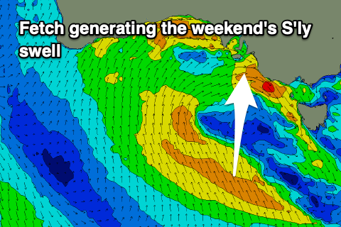
 We'll see the broad, though weakening low pushing east this evening, with us falling under it's backside during the weekend. This will result in a drop in W'ly swell tomorrow, but down South, some new S'ly swell is due to build, generated by a fetch of weakening S/SE winds pushing east, through our southern swell window today.
This should generate a building S'ly swell tomorrow, reaching 3-4ft into the afternoon across the South Coast, easing back from 3ft on the sets Sunday. The Mid Coast should ease back from 2ft to occasionally 3ft tomorrow morning and winds look to be gusty from the W/NW-W, favouring protected spots on the South Coast all day.
Lighter winds are due into Sunday morning, likely tending light S/SE on the Mid with easing 1-2ft sets and light W/NW down South. Winds should remain light most of the day across both coasts, creating fun surf, from the W on the Mid and SW down South.
Monday should be nice and clean again down South with fading 2ft sets and a N/NW tending NW breeze. The Mid Coast will be tiny.
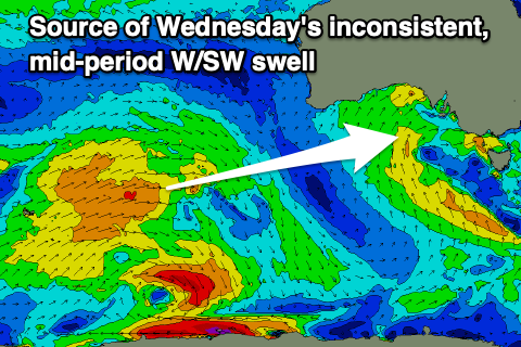
 Now, our inconsistent pulse of W/SW groundswell for Monday afternoon and secondary better pulse for Tuesday afternoon are on track, with the first smallest swell generated by a brief fetch of W'ly gales around the Heard Island region. A broader and more prolonged fetch of strong W/SW winds rotating around a polar low is the source of the second swell into Tuesday afternoon.
Monday's looks small and only to 1-2ft across the South Coast Monday afternoon, similar Tuesday morning with tiny waves on the Mid Coast. The afternoon pulse should provide better 2ft to occasionally 3ft sets, easing from a similar size Wednesday morning.
Conditions will be favourable for the South Coast with gusty N/NE-NE winds all day Tuesday, stronger N/NE tending N/NW on Wednesday making it a little trickier.
Longer term, a mid-latitude low firing up towards Western Australia should generate a fun, moderate sized W/SW swell for next weekend under north-west winds, but we'll have a closer look at this on Monday.
For a more comprehensive run down of why we're having such an average run of swell, check out this article. Have a great weekend!

