Best Sunday, with windy west swells next week
South Australian Surf Forecast by Craig Brokensha (issued Friday Jul 8th)
Best Days: Keen surfers tomorrow morning down South, Sunday down South, Wednesday both coasts
Features of the Forecast (tl;dr)
- Easing small, S windswell tomorrow with light-mod S winds (possibly variable at times in the AM)
- Inconsistent, small SW groundswell tomorrow and Sun AM, easing Sun PM and tiny Mon
- Moderate N/NE tending N/NW winds Sun
- Strengthening N/NW tending NW winds Mon
- Moderate sized W/SW groundswell and mid-period swell Tue with strong SW winds, shifting S/SW later
- Easing W/SW swell Wed with variable tending W/NW winds on the Mid, W/NW tending variable winds down South
- Smaller Thu with NW winds
Recap
Poor surf the last two days down South with gusty onshore winds and a small lift in localised windswell today. The Mid Coast has been tiny and forgettable.
This weekend and next week (Jul 9 - 15)
Onshore winds will ease off overnight and they'll be lingering out of the S'th tomorrow morning though possibly tending variable at times before lunch. There'll be a weak S'ly windswell to 2ft or so, while some inconsistent mid-period SW swell will also be in the mix, generated by a distant but healthy frontal progression south-west of Western Australia.
Infrequent 2ft to occasionally 3ft sets are due across Middleton, easing through Sunday while the Mid Coast comes in at 0.5-1ft max.
Winds will improve on Sunday and swing offshore from the N/NE, shifting N/NW through the day, but get in early for the most size.
Our strengthening N/NW tending NW breeze is due on Monday but with a low point in swell, tiny across Middleton with 1ft sets.
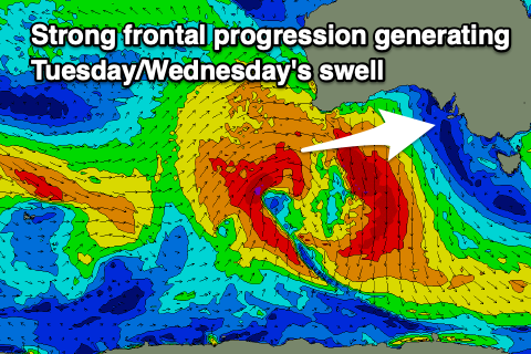
 A late onshore W/SW change is due and this is associated with a vigorous but weakening frontal progression moving in from the west, bringing poor SW winds Tuesday, shifting S/SW through the afternoon.
The swell from this frontal progression is looking a little better with a fetch of strong to gale-force W/SW-SW winds due to move through our swell window, generating a moderate sized W/SW groundswell for Tuesday, mixed in with some mid-period swell.
The Mid Coast should see 2-3ft waves but with those poor winds, easing from 2ft on Wednesday with much better winds, variable and light offshore ahead of weak W/NW sea breezes.
The South Coast isn't due to see much size from this system with 2-3ft sets across Middleton, best Wednesday with light W-W/NW winds through the morning.
We'll see the swell continuing to ease into Thursday with NW winds ahead of the next approaching front.
Some new, fun mid-period W'ly swell is due Friday in the wake of the change ahead of a stronger cold outbreak but we'll have a closer look at this on Monday. Have a great weekend!

