Building westerly swells this week
South Australian Surf Forecast by Craig Brokensha (issued Monday June 20th)
Best Days: South Coast tomorrow and Wednesday, Mid Coast Wednesday morning, South Coast Saturday and Sunday morning, Mid Coast later Sunday and Monday
Features of the Forecast (tl;dr)
- Building, moderate sized mid-period W swell this afternoon, holding tomorrow, easing Wed
- Fresh W/NW-NW winds tomorrow, lighter Wed (possibly NE early on the Mid Wed)
- Low point in swell Thu with stronger N/NW winds
- Moderate to large sized W/SW groundswell building Fri with fresh W/SW winds, holding Sat AM with fresh NW winds
- Reinforcing, moderate sized W/SW swell Sun with NW tending S winds, easing Mon with E/NE winds
Recap
Tiny surf on the Mid Coast, and while the South Coast was expected to remain tiny Saturday, sets to 2ft to occasionally 3ft off Middleton Point had me puzzled. That was until I checked the Cape du Couedic wave buoy and saw a long-period SE groundswell signal.
This was amazingly generated south-southeast of New Zealand early last week, wrapping around Tasmania, up and into us on Saturday. I'll do a more detailed analysis on this rare swell during the week. Conditions were clean with gusty offshore winds, with tiny waves seen yesterday as it faded.

Cape du Couedic wave buoy picking up the SE groundswell signal at around 16s
This week and weekend (Jun 21 - 26)
Today we’ve got a weakening mid-latitude low pushing in from the west, bringing gusty NW tending W/NW winds and a building NW windswell across the Mid Coast.
The South Coast is clean but tiny though we should see a new, mid-period W’ly swell building through this afternoon, generated by a distant frontal progression (west-southwest of WA) and fetch of strong to sub-gale-force W/SW-W winds through our western swell window.
The Mid should see 2ft+ surf this afternoon and tomorrow, easing back from 2ft on Wednesday, with the South Coast seeing 2-3ft sets across Middleton.
Winds tomorrow will still be onshore but weaker across the Mid Coast and from the W/NW-NW, with protected spots down South being cleanest.
Similar but lighter winds are due on Wednesday with a lighter NE’ly likely across the Mid Coast through the morning. It will be a little lumpy but still worth a paddle.
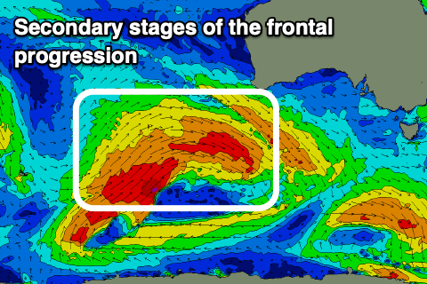
Thursday looks to be smaller and a low point in swell with strengthening N/NW winds ahead of the next approaching cold front, which will push through early Friday, leaving gusty W/SW winds in its wake.
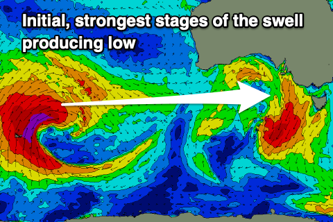
 This frontal progression will bring with it a mix of inconsistent W/SW groundswell mixed in with mid-period energy, all generated by the same system. This is a strong low that’s formed north of the Heard Island region, producing a fetch of gale to severe-gale W’ly winds in our far swell window, with it due to move slowly east over the coming days. This will see a continuous fetch of gale-force W/NW winds projected towards us, with broad, strong W/SW winds then moving under the country later week.
A wide variety of periods and sizes are expected from Friday though moderate to large in size and from the W/SW. We should see the Mid Coast building to 2-3ft on Friday afternoon but with those W/SW breezes, a similar size Saturday but still bumpy with W/NW winds.
 Middleton should build to 3-5ft on Friday afternoon and hold a similar size Saturday morning, cleanest through Saturday with fresh NW winds, then NW tending S on Sunday.
We’ve got some reinforcing swell on the cards for Sunday and winds will become more favourable on the Mid in the wake of the S’ly change, swinging offshore Monday and with surf to 2ft+. We’ll have a closer look at this on Wednesday though.


Comments
My head is still spinning at that swell that popped up.. crazy
Hey team I received your email forecast update but the link is still pointing to Monday's forecast, not Wednesday's.
Agh, I stuffed that up sorry. Here's the latest.. https://www.swellnet.com/reports/forecaster-notes/south-australia/2022/0...