Slow improving surf down South, large next weekend
South Australian Surf Forecast by Craig Brokensha (issued Friday April 22nd)
Best Days: Today Mid Coast, South Coast Sunday morning for the keen, South Coast Monday and Tuesday mornings, Mid Coast next weekend, South Coast next Sunday
Features of the Forecast (tl;dr)
- Easing mid-period W/SW and S/SW swells tomorrow with mod-fresh E/SE tending SE winds
- Inconsistent SW groundswell building Sun PM with moderate E/NE tending E/SE-SE winds
- Inconsistent mid-period S/SW swell for Sun PM, easing Mon with a small reinforcing pulse Tue AM
- Easing, inconsistent SW groundswell Mon with NE tending E/SE winds, N/NE tending E/SE Tue
- Low point in swell Wed with gusty N/NE winds
- Building NW windswell Thu with fresh to strong NW winds
- New, mid-period W'ly swell building Fri with NW tending SW winds
- Large W/SW groundswell filling in Sat with SW tending S/SE winds, easing Sun with E/NE-NE morning winds
Recap
Our large S/SW groundswell mixed in with mid-period W/SW swell filled in yesterday right on cue along with the predicted favourable winds. The Mid Coast offered super fun 2ft sets into the afternoon with the incoming tide while the South Coast pulsed to 6ft with 8ft sets breaking on a select few deep water reefs. Conditions become bumpy into the afternoon with sea breezes.
Today the swell is on the ease but with average conditions down South thanks to a fresh E/SE breeze along with 1.5ft+ sets on the Mid Coast.


Take your pick yesterday
This weekend and next week (Apr 23 - 29)
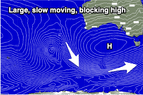
Moving into the weekend and we'll see both our W/SW swell and S/SW swell easing in size and energy but with average, moderate to fresh E-E/SE winds persisting thanks to a broad, slow moving high sitting in the Bight.
The Mid Coast will be back to 0.5-1ft while the South Coast should ease from 3ft on the sets.
 The high will start moving slowly ease through Sunday and more so into next week, allowing winds to slowly improve down South. It'll still be cross-offshore and lumpy/peaky Sunday morning with a moderate E/NE breeze and temporary low point in swell to 2ft or so across Middleton.
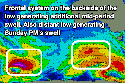
Into the afternoon, our inconsistent SW groundswell is due to fill in, generated by a strong but distant polar low that fired up south-east of the Heard Island region during the middle of the week. There'll be long waits for the sets but Middleton should build to 3ft into the afternoon but with an E/SE-SE breeze. The Mid Coast isn't due to see any size from this source with tiny to flat conditions.
 There'll also be some smaller mid-period S/SW swell in the mid Sunday afternoon through Tuesday, generated by continued polar frontal activity south-west of Tasmania today and on the weekend. While not ideally aligned in our swell window this should provide additional 2-3ft sets Sunday afternoon and Monday morning, easing to 2ft Tuesday.
Winds will continue to slowly improve for the South Coast as the high moves east with a NE offshore Monday morning N/NE on Tuesday as the swell becomes smaller.
The blocking effects of the high will be realised into the middle of the week with the swell due to bottom out Wednesday and Thursday under strong N/NE winds on the former and N/NW winds on the later as a trough/low starts approaching from the west.
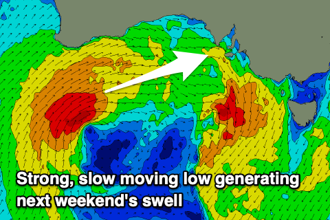
This will signal the start of a significant progression of mid-latitude storms moving in from the west mid-late week and into the weekend, bringing moderate to large levels of W/SW groundswell from Friday.
The first system is forecast to strengthen just west of us on Thursday, bringing a spike of mid-period swell Friday to 2ft+ into the afternoon but with fresh NW winds, while the South Coast won't see much size owing to the acute westerly nature of the swell. Middleton may see 2ft sets.
 A much stronger front/low moving in behind this initial system should generate a large W/SW groundswell for Saturday afternoon and Sunday to 3-4ft on the Mid Coast, more so to 4ft across Middleton owing to the swell direction.
Locally winds look to swing SW to S/SE at some stage through Saturday in the wake of the weakening system, E/NE-NE Sunday but we'll confirm this and the swell size on Monday. Have a great weekend!

