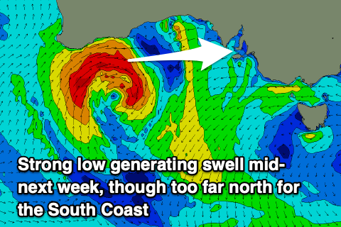
Upgrade in westerly swell next week
South Australian Surf Forecast by Craig Brokensha (issued Friday February 4th)
Best Days: Sunday morning South Coast, similar Monday morning for the keen and desperate, Wednesday afternoon Mid Coast, Thursday Mid Coast
Features of the Forecast (tl;dr)
- Small levels of S/SE windswell tomorrow with light-mod E/SE-E winds and strong S/SE sea breezes
- Easing S/SE windswell Sun and Mon with morning NE-N/NE winds and afternoon sea breezes
- Tiny Tue with fresh N/NE tending variable winds
- Mod-large W/SW groundswell building Wed with W/NW tending fresh SW winds, easing Thu with S/SE winds
Recap
Terrible conditions persisted across the South Coast yesterday with a strong onshore wind and junky S'ly windswell to 2-3ft while the Mid Coast was tiny and to 0.5ft.
Today winds have shifted E/SE across the South Coast creating slightly better conditions in protected spots with similar amounts of S/SE windswell, flat on the Mid Coast.
This week and next (Feb 5 - 11)
Moving into the weekend we'll see a strong, broad high that's been responsible for our run of poor winds and cool weather sliding east, allowing winds to swing more east to north-east over the coming days. This will also bring warmer, finer weather.
Tomorrow morning still looks a touch bumpy with lighter E/SE-E winds ahead of strong afternoon/evening S/SE sea breezes. Sunday looks cleaner with a light NE-N/NE breeze before sea breezes kick in.
Swell wise, we'll see locally generated levels of slowly easing S/SE windswell as the infeed of S/SE winds are cut off for longer each day due to the improving morning winds. Tomorrow looks to come in around 2ft to occasionally 3ft, with Sunday easing from 2ft+.
Come Monday the surf looks to be easing from 1-2ft and with a favourable N/NE-NE offshore again on the coast.
Tuesday will offer N/NE offshore winds but there'll be no swell to surf with it bottoming our across the South Coast. As we move into Wednesday a very intense but weakening mid-latitude low will push in from the west, bringing a moderate W/NW tending SW change and some strong new W/SW groundswell.
 This has been upgraded since the weekend, with a trough pushing towards Western Australia on Sunday due to form into a severe low into the evening and Monday.
Initially it'll be too far north of our swell window, but come Monday we'll see a significant fetch of severe-gale W/SW winds projected through our western swell window weakening through Tuesday while dipping south-east.
A moderate to large W/SW groundswell is now expected, with it due to build strongly Wednesday, peaking overnight before easing Thursday but still being solid.
Size wise the Mid Coast should build to a solid 3ft+ into the afternoon on Wednesday, easing from 2-3t on Thursday while the South Coast will miss a lot of the size owing to the westerly nature and blocking effects of Kangaroo Island. We're looking at 2-3ft waves across Middleton late Wednesday and Thursday morning.
Coming back to the local winds and those onshore breezes Wednesday, shifting S/SE on Thursday, favouring the Mid Coast.
Friday will remain onshore from the SE down South as the swell eases with cleaner conditions due on Saturday but with small, weak leftovers.
Longer term it looks like the Southern Ocean will fire up into next weekend, producing some better swells into the following week. More on this in next week's updates. Have a great weekend!


Comments
That's more like it Craigo! :)
Ok, Welcome a change of swell source. Changes it up a bit.
South coast WA- might be a bit of wind cheers in advance