Average start to the New Year
South Australian Surf Forecast by Craig Brokensha (issued Friday December 31st)
Best Days: Today South Coast magnets, Mid Coast for the keen Monday and Wednesday
Features of the Forecast (tl;dr)
- Fading surf tomorrow with variable morning winds ahead of sea breezes
- Late increase in W/SW swell Sun, peaking Mon with mod-fresh SE tending strong S/SE winds
- Smaller Tue with strong S/SE winds
- Reinfrocing SW swell filling in Wed, easing Thu with fresh S/SE tending strong S winds
Recap
A tiny hint of swell on the Mid Coast yesterday, pulsing to 1ft into the afternoon with glassy, hot conditions while the South Coast was really fun though the morning with a mix of swells to 2-3ft.
Today conditions are hot and clean again down South but with a leftover 1-2ft swell, best on the swell magnets while the Mid Coast is flat.

Clean peaks this AM
This week and weekend (Jan 1 - 6)
The coming forecast period isn't too flash to kick off the New Year.
Firstly looking at the weekend and we should see variable winds and clean conditions across the Surf Coast again tomorrow morning but swell wise it'll be tiny. Middleton only looks to be 1-1.5ft max with not much more size on offer elsewhere.
 We'll see afternoon sea breezes kick in while come Sunday a trough will bring a freshening S/SW change that will become stronger into the evening as a high pressure starts to fill in from the west.
Unfortunately this high won't be able to continue east owing to a tropical low forming in the Coral Sea, tracking slowly down the East Coast. This will squeeze the eastern flank of the high, generating strong S/SE winds from Monday through Wednesday, though each morning winds look to abate a little and be more fresh in nature.
Moderate levels of S/SE windswell will be kicked up by these winds, while also spoiling a couple of pulsed of mid-period SW swell.
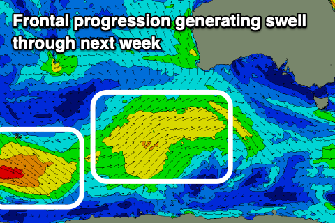
The first and best aligned for the Mid Coast is due to kick later Sunday but peak Monday, generated by a a broad through weak frontal progression pushing up and under Western Australia today, weakening through tomorrow.
Size wise it only looks to be 1-1.5ft when it peaks on Monday and the big morning high and lower afternoon high won't be favourable for squeezing 2ft sets out of it. Conditions will be OK though with moderate to fresh SE tending stronger S/SE winds. The South Coast may see 2-3ft sets across Middleton but there'll be larger levels of local windswell.
 The swell looks to ease into Tuesday but a secondary pulse of mid-period energy should be seen into Wednesday and Thursday. This will be generated by a secondary, fetch of slightly strong W/SW winds pushing up on the back of today's progression and should maintain 1-1.5ft sets across the Mid Coast while providing 3ft+ waves across Middleton.
There'll be no improvement in the local winds for the South Coast though with strong S'ly breezes on Wednesday, possibly weakening a touch Thursday and swinging S/SW but this will be temporary.
Longer term high pressure looks to dominate our state into next weekend and the week after, bringing persistent winds from the south-eastern quadrant and no real significant swell.
A broader polar low developing around the Heard Island region next week may produce some new swell for next Sunday but we'll have a closer look at this Monday. Have a great New Year!

