Tricky period of wind with incoming swells having a touch more west
South Australian Surf Forecast by Craig Brokensha (issued Monday December 13th)
Best Days: Mid Coast late tomorrow, Mid Coast beginners Wednesday, Friday both coasts (beginners Mid), Mid Coast Sunday
Features of the Forecast (tl;dr)
- Weak W/SW-SW swell building tomorrow, easing Wed with SE tending S/SE winds down South (SE tending SW and then S/SE-SE on the Mid)
- S/SE winds Wed
- E/NE tending S/SE winds Thu with an inconsistent SW groundswell building into the PM, easing Fri with fresh NE winds
- Moderate sized, inconsistent W/SW groundswell building Sat with strong but abating SW winds, peaking Sun with S/SE tending SW winds
Recap
Improving conditions all weekend down South with a moderate sized S/SW groundswell for Saturday morning with lumpy, peaky conditions under a cross-offshore wind, much better yesterday with a secondary pulse of reinforcing S/SW swell and cleaner, smoother conditions. The Mid Coast was tiny Saturday and flat yesterday.
Today an onshore change has moved through with a drop in swell down South, tiny and bumpy on the Mid Coast.
This week and weekend (Dec 14 – 19)
Now that an onshore change has moved through we're set for a generally poor week of waves for the South Coast, improving late week and for the Mid Coast, a little more into the weekend.
 Winds are due to ease tomorrow and tend SE, light in nature as a new, weak W/SW swell fills in.
The source of this swell is a stalling mid-latitude low south of the Bight today, aiming a fetch of W/SW winds through our western then south-western swell window. We should see building levels of swell tomorrow, reaching 1ft to nearly 2ft on the Mid Coast into the afternoon and 2-3ft across Middleton.
Afternoon sea breezes will create bumpy conditions on the Mid Coast, improving late as winds shift S/SE-SE.
The swell will fade Wednesday from 1-1.5ft on the Mid and a similar 2-3ft down South but with unfavourable S/SE winds for the South Coast.
Thursday now looks a bit cleaner on the South Coast with an E/NE offshore but the swell will be at a temporary low point.
A new, inconsistent SW groundswell is due to build through the day Thursday, generated by a strong low that formed in our far, far swell window, south-east of South Africa late last week. A fetch of gale to severe-gale W'ly winds were produced on the weekend but the low has since broken down south-west of Western Australia with the groundswell now heading towards us.
It'll be inconsistent and looks to be more favourable aimed for the South Coast than the Mid Coast. Infrequent sets to 1-1.5ft are due on the Mid Coast Thursday afternoon with 2-3ft sets across Middleton, easing from a similar size on Friday down South but holding 1-1.5ft on the Mid.
Afternoon sea breezes will get into the new swell on Thursday, improving late in the day on the Mid, with Friday offering cleaner conditions with NE winds blowing across both coasts.
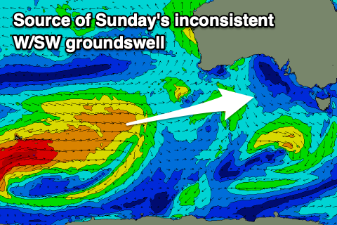
 As touched on last update, a better W/SW groundswell is due into next weekend, produced by a secondary strong frontal progression and polar low firing up on the tail of the weakening low linked to Thursday/Friday's swell.
A great fetch of initially gale to severe-gale W/SW winds will be generated around the Heard Island region, weakening a touch while moving further north-east into our western swell window.
A good W/SW groundswell should arrive later Saturday and build to 1-2ft by dark on the Mid Coast, 2ft+ down Middleton with Sunday seeing 2ft waves on the Mid, 3-4ft waves across Middleton.
Unfortunately a cold front will bring strong SW winds for dawn Saturday, abating through the day with more favourable S/SE winds on Sunday (with SW sea breezes during the day).
Longer term the models diverge a little regarding the formation of a mid-latitude low in the Bight later in the weekend, but we'll have a closer look at this Wednesday.


Comments
The dreaded summer gutter has already arrived all the way along between Goolwa and Middleton. Take off, two turns if you are lucky, then the waves go flat into deep water...sigh...
The mid is looking super fun right now, while i'm stuck at work... :-(
Yeah that little swell has come in real nice.