Options across both coasts this period
South Australian Surf Forecast by Craig Brokensha (issued Monday November 29th)
Best Days: South Coast tomorrow and dawn Wednesday, Mid Coast Friday and Saturday morning
Features of the Forecast (tl;dr)
- New, mid-period SW swell for this afternoon, holding tomorrow with N/NE tending variable NW winds
- Easing swell Wed with early variable winds ahead of a S/SW change
- S/SW winds Thu with a late increase in W/SW swell, peaking Fri with gusty S/SE winds
- Easing W/SW swell Sat with fresh SE tending S/SE winds
- Smaller Sun with E/SE tending S/SE winds
Recap
Average surf most of the weekend with an easing S/SE windswell Saturday with lingering onshore winds, a touch cleaner yesterday morning but small. The Mid Coast was clean but tiny all weekend.
Today conditions were much cleaner down South, with a small fun swell, best on the exposed beaches. We should see more size this afternoon but with afternoon sea breezes. More on this below.
This week and weekend (Nov 30 – Dec 5)
Our expected pulse of mid-period swell for tomorrow has been brought forward a little with the frontal progression linked to it racing in a little quicker than expected over the weekend.
A great, elongated fetch of off axis W/NW gales is responsible for the swell and while not ideally aimed, we should see a fair bit of energy spreading up radially into us.
The swell should build this afternoon and reach 2ft+ across Middleton, with a peak tomorrow to 2ft to occasionally 3ft. The swell generating fetch wasn't in a favourable for the Mid Coast with tiny 0.5-1ft sets due.
We'll see the swell easing into Wednesday from a small 2ft across Middleton, smaller Thursday.
Conditions will be best tomorrow so make the most of it with a N/NE tending NW breeze, variable into the evening. Wednesday looks a touch dicey with early variable winds, swinging S'ly by mid-morning and increasing through the day. So go the early if you're up for a surf.
This change will be as a trough moves in from the west, followed by a high, bringing unfavourable S/SW winds Thursday and better (for the Mid Coast) S/SE breezes on Friday.
 Our new W/SW swell is still on track, generated by a broad, slow moving but distant polar low that's formed around the Heard Island region.
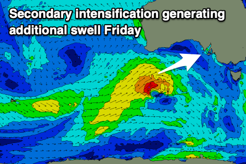
Currently this low is generating a great fetch of W/SW gales but will weaken as it moves east over the coming days. A small intensification on the backside of the weakening progression during the middle of this week should produce an additional, more consistent pulse of W/SW swell for Friday, with a mix of energy due to fill in, peaking through the middle of the day/afternoon.
We should see some signs of new swell arriving Thursday afternoon with sets likely to build to 1-1.5ft on the Mid Coast but Friday should see better 2ft surf and fairly consistent.
 There's the chance for the odd bigger one with the help of the tide and protected spots will be best with that S/SE breeze. Easing surf from 1-2ft is due on Saturday as winds shift more SE (S/SE into the afternoon).
The South Coast looks to come in around 3-4ft at the peak of the swell but conditions will be poor with those winds.
Unfortunately besides a slight swing in winds to the E/SE on Sunday morning, another trough looks to bring a return to S/SE winds next week, spoiling some fun, new SW swell. More on this in the coming updates though.

