Get stuck in the coming days
South Australian Surf Forecast by Craig Brokensha (issued Monday November 22nd)
Best Days: South Coast tomorrow until late afternoon, South Coast Wednesday morning, Mid Coast for beginners Thursday and Friday morning
Features of the Forecast (tl;dr)
- Building S/SW groundswell tomorrow PM with light NE-N/NE tending N/NW winds ahead of weak sea breezes, strengthening later
- Easing S/SW groundswell Wed with variable tending S winds late AM, freshening into the PM
- Building S/SE windswell Thu, solid and peaking Fri with strong S/SE winds
- Tiny, inconsistent W/SW groundswell Thu on the Mid
- Easing mix of swells Sat with fresh SE winds, smaller Sun with a light E/NE wind in the AM
Recap
Nothing to surf on the Mid Coast while the South Coast was poor and onshore with nowhere to recommend.
Today conditions are cleaner down South with a light E/NE breeze and mix of S/SE windswell and mid-period S/SW swell to 2-3ft.
This week and weekend (Nov 23 - 28)
We've seen conditions slowly improve over the last two days as winds swung SE yesterday and then E/NE this morning. Into tomorrow we should see winds improve further as a weakening mid-latitude low pushes in slowly from the west.
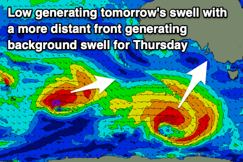
A light NE-N/NE tending variable N/NW breeze is due tomorrow morning ahead of weak afternoon sea breezes, a little fresher into the evening. This will be as a good, new S/SW groundswell fills in, generated by a healthy polar low that formed under the country on the weekend. It formed a little later than ideal in our swell window with fetches of gale-force W-W/NW winds tracking east-southeast through our swell window.
 This is off axis to our swell window but we should still see a good lift in size through the afternoon with sets pushing to 3ft across Middleton, up from a smaller 2ft+ in the morning. The Mid Coast will be tiny to flat owing to the southerly nature of the swell.
Come Wednesday the swell should be easing from the 3ft range across Middleton and we should see an early window of variable winds through the morning before a trough brings a shallow S'ly change late morning, freshening into the afternoon.
From Thursday through Saturday we'll see a strong high moving in from the west squeezing the deepening trough which will form into a low off the far south NSW coast.
This will bring strong S/SE winds that will be at their worst on Friday, kicking up a moderate sized +, junky S/SE windswell across the South Coast.
The low in the Tasman Sea should slowly track south-east toward New Zealand on the weekend allowing winds to abate and swing more SE Saturday (still fresh) and then possibly lighter E/NE on Sunday morning.
Unfortunately swell wise there's nothing of size due to be left by Sunday with the S/SE windswell fading as winds ease leaving weak, easing 2ft sets across Middleton.
In the meantime, the Mid Coast looks to offer a tiny wave for beginners Thursday, with a strong but short-lived low that fired up south-west of Western Australia yesterday due to provide inconsistent 1ft+ sets, fading from 1ft on Friday.
Following Sunday's respite in winds it looks like a new trough and ridge will move in Monday bringing a fresh flush of S/SE winds with a possible new mid-period SW swell. It'll clean up when fading again, but more on this Wednesday.

