Poor weekend, improvement in winds for early next week
South Australian Surf Forecast by Craig Brokensha (issued Friday November 19th)
Best Days: Keen surfers Monday morning down South, Tuesday down South
Features of the Forecast (tl;dr)
- Building S/SW swell tomorrow but with fresh SE tending stronger S/SE winds
- Easing S/SW swell and junky S/SE windswell Sun with fresh SE tending stronger S/SE winds
- Mix of small swells Mon with light-mod E/NE tending S/SE winds
- Building S/SW groundswell Tue with N/NE tending variable winds
- Easing S/SW groundswell Wed with strengthening SW winds
Recap
A small window of clean, small waves at dawn yesterday down South before winds quickly strengthened, blowing out conditions through the morning and then swinging westerly into the afternoon and then south-east today.
The Mid Coast was near flat and choppy yesterday, cleaner today but again tiny to flat.
This weekend and next week (Nov 20 - 26)
This is the final look at the inland low and local winds for tomorrow on the South Coast and unfortunately they've stuck with the ECMWF solution, hanging further north which will see poor, fresh SE tending stronger S/SE winds developing across the region.
Our mid-period S/SW swell is on track, with the polar front linked to it currently pushing under Tasmania, with an increase in size due through the afternoon, reaching 3ft across Middleton late afternoon. The Mid Coast (which will be clean) won't see any size with the swell being too south and blocked by Kangaroo Island.
The swell looks to still be around 3ft Sunday morning, but easing, mixed in with some localised S/SE windswell. There'll be no improvement in conditions with moderate to fresh SE tending strong S/SE winds again.
We're now looking at a window of cleaner conditions early next week as a low that was forecast to form off the East Coast, squeezing a high south of us hangs further north. This will allow winds to swing lighter E/NE on Monday morning but there'll only be a small, weak mix of swells to 2ft across Middleton.
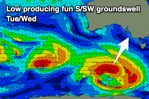
 Tuesday looks cleaner with a light N/NE offshore, possibly remaining variable into the afternoon as a new S/SW groundswell fills in.
This will be generated by a strengthening low dipping south-east under the country through the weekend. A great though less than ideally aligned fetch of gale to near severe-gale W/NW winds will be projected through our southern swell window, with the swell due to build through the day, reaching 3ft across Middleton into the afternoon. Hopefully the wind forecast stays true but we'll confirm this on Monday.
On Wednesday we'll see a trough moving in, bringing a S/SW change that'll freshen through the day, creating deteriorating conditions as the S/SW groundswell starts to ease.
A slow moving high will take its time ridging in from the west resulting in persistent onshore SW tending S/SE winds through the end of the week along with moderate pulses of reinforcing SW swell. The Mid Coast may see a tiny 1ft+ wave later week but we'll confirm this Monday.
Looking longer term there's still nothing major on the cards for the state, but we'll have another look at this Monday. Have a great weekend!

