Fun waves to kick off the weekend, less so next week
South Australian Surf Forecast by Craig Brokensha (issued Friday November 5th)
Best Days: Today, both coasts tomorrow morning, Mid Coast late Sunday and early Monday, South Coast Tuesday morning (beginners on the Mid)
Features of the Forecast (tl;dr)
- Easing mid-period W/SW swell tomorrow with variable winds ahead of a strengthening SW change early afternoon
- Building mid-period W/SW swell Sun PM with S/SE winds
- Easing mid-period W/SW swell Mon with light-mod SW winds (S/SE early on the Mid)
- New SW swell Tue with variable winds giving into a strengthening S'ly change in the PM
- Easing surf Wed with S'ly winds, persistent out of the S/SE into the end of the week and gusty
Recap
Poor surf down South with an onshore wind and small swell yesterday morning, much better on the Mid Coast with a new pulse of mid-period W/SW swell offering 1-1.5ft waves which pulsed to 1-2ft into the afternoon and evening as winds remained favourable.
Early this morning before the tide got to it, the Mid offered great 2ft waves with clean conditions but this is now slower and back to 1-2ft as the tide runs out. The afternoon should remain fun as out best pulse of W/SW swell keeps the surf around 2ft with weak sea breezes and late S/SE winds. The South Coast was also cleaner with lighter winds and 2-3ft sets across Middleton.

Dawn session for the win

Ocean sweepers
This weekend and next week (Nov 6 - 12)
Today's best pulse of mid-period W/SW swell was generated by the strongest of the fronts in a relatively weak frontal progression that pushed up and under Western Australia through this week.
 We'll see the swell easing through tomorrow back from a less consistent 1-2ft on the Mid Coast and 2-3ft across the Middleton stretch along with favourable winds. Light, local offshore winds are due (NE tending NW on the Mid Coast) before giving into a strengthening SW change as a trough pushes through early afternoon.
The trough will clear to the east on Sunday allowing winds to ease and swing S/SE-SE across the Mid Coast, while persisting from the S'th down South.
A new pulse of mid-period W/SW swell will arrive through the afternoon, generated by relatively weak but persistent fronts firing up on the tail of the frontal progression linked to today's swell, with fetches of strong to near gale-force W/SW winds projected through our western and then south-western swell windows.
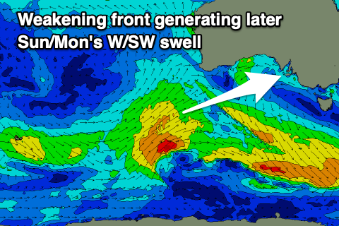
 The first of these is currently being generated by a frontal system that's south-southwest of Western Australia.. A weakening fetch of strong to near gale-force W/SW winds are being generated through our swell window, with a fresh pulse of W/SW swell due Sunday afternoon/evening to 1-2ft on the Mid, pulsing to 2-3ft down South on dark.
This swell is due to ease back from 1-2ft Monday on the Mid Coast and 2-3ft down South with lighter SW winds. The Mid is likely to see early S/SE winds again before shifting back to the SW.
A secondary pulse of slightly stronger SW swell is due on Tuesday, produced by a stronger low moving under the country Sunday, generating strong to gale-force W/SW winds. This will be a little less favourably aligned for the Mid Coast with 1-1.5ft sets due through the day, while the South Coast should offer better 3ft sets across Middleton.
 With variable morning winds, it'll be worth making of down South before another trough and strong high starts edging in from the west into the afternoon, bringing strengthening S'ly winds that will then persist into the end of the week from the S/SE.
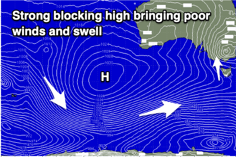
The longer term outlook is poor owing to the strong, blocking high edging in mid-late next week, blocking our main swell windows and extending well south-west of Western Australia. Therefore make the most of today and the coming waves. Have a great weekend!


Comments
Nice thunderstorms in the northern part of the Gulf, via our Christies cam.