First the South Coast, then the Mid Coast
South Australian Surf Forecast by Craig Brokensha (issued Monday November 1st)
Best Days: South Coast tomorrow (beginners Mid Coast) and Wednesday morning, Mid Coast possibly late Thursday but more so Friday and Saturday, South Coast Friday morning and Saturday
Features of the Forecast (tl;dr)
- Building SW swell this afternoon with SE winds, easing tomorrow with mod-fresh NE tending N/NE winds (variable later)
- Easing swell Wed with variable N/NE winds ahead of a late morning SW change
- Low point in swell Thu AM with S/SE winds
- Late increase in new W/SW swell Thu, peaking through Fri, easing slowly Sat
- E winds ahead of sea breezes Fri, N/NE tending variable Sat
Recap
There's been quite a bout of dynamic weather while I was on leave, with severe storms smashing the state through the end of last week.
The weekend saw more subdued weather and winds in the wake of a severe low, but surf wise Saturday wasn't great with lumpy 2-3ft leftovers down South, tiny on the Mid Coast. Sunday was better on the exposed beaches down South with cleaner conditions and a small 2ft of swell, 0.5-1ft on the Mid Coast and ideal for beginners.
Today the surf is tiny and ideal for beginners again on the Mid with 0.5-1ft sets, clean and to 2ft again across Middleton, best on the swell magnets. A new SW swell has since started to show on both coasts and on the Cape du Couedic buoy.
This week and weekend (Nov 2 - 7)
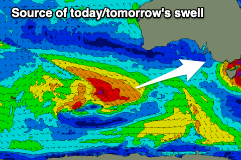
 We've got a new SW swell on the build this afternoon, generated by a multi-staged frontal system pushing in from the south-west of Western Australia on the weekend.
The swell generating fetch was aimed mostly towards Victoria, with fetches of W/NW gales projected side on to our swell window but we should still see some decent size spreading radially into us, pushing to 3ft+ across Middleton this afternoon, easing from a similar size tomorrow morning. The Mid Coast should offer 1-1.5ft sets on the favourable parts of the tide with the swell just a touch more south in direction than ideal.
Winds look favourable most of the day and moderate to fresh from the NE tending N/NE down South, variable into the late afternoon, while the Mid should see NE tending variable winds.
The swell will ease through the day, with Wednesday seeing smaller, fading surf from 2ft on the sets across Middleton, tiny on the Mid with light, morning offshore winds ahead of a trough and SW change late morning.
Thursday looks to be a lay day with a low point in swell and S/SE winds in the wake of the trough.
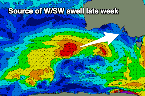
Later in the day the Mid Coast may see a tiny increase in new W/SW swell but Friday and Saturday are better chances to surf as some fun, mid-period energy fills in from under Western Australia.
 We'll see another multi-staged frontal progression pushing up and under Western Australia over the coming days, though relatively weak in nature. The favourable projection through the Mid's swell window should produce fun 2ft surf Friday (possibly 1-1.5ft late Thursday), easing back slowly from 2ft on Saturday.
The South Coast will miss a bit of the size and likely build to 2-3ft across Middleton through Friday, easing from a similar size Saturday morning.
Winds will be great for the Mid Coast on Friday and E/SE ahead of weak sea breezes (E/NE during the morning down South), N/NE tending variable on Saturday as the swell eases ahead of a trough/low. It looks like winds will deteriorate into Sunday as the low/trough moves in, but we'll have a closer look at this on Wednesday.
Longer term there's plenty more mid-period swell energy on the cards, but more on this next update.

