Maximise the coming westerly swells
South Australian Surf Forecast by Craig Brokensha (issued Wednesday October 13th)
Best Days: Both coasts tomorrow morning, possibly the Mid Coast Friday morning, Sunday/Monday/Tuesday mornings on the South Coast
Features of the Forecast (tl;dr)
- Building W/SW groundswell late today with gusty NW winds, holding tomorrow AM
- Reinforcing W/SW groundswell tomorrow PM with E/NE tending SW winds on the Mid, strengthening later, N/NE tending S/SE down South, strengthening later
- Easing W/SW swells Fri with strong S/SW winds (possibly S/SE for a period on the Mid in the AM)
- Inconsistent SW groundswell Sat with fresh to strong S/SW winds, easing through the day
- Easing SW groundswell Sun with N/NE tending SE winds (E/NE on the Mid), smaller Mon with variable morning winds
- Small sized S/SW swell Mon PM, easing Tue with gusty E/NE - NE winds
Recap
The South Coast faired the best yesterday with clean, fun 2ft waves across the Middleton stretch under all day offshore winds as the swell eased further into the afternoon. The Mid Coast was tiny and to 1ft most of the day, best for beginners.
Today, a mid-latitude low that's formed to our west is slow moving towards us, bringing today's fresher NW winds and wet weather. The swell is at a low point though we should see a good W/SW groundswell building through the late afternoon on the Mid Coast, discussed in more detail below.

Cape du Couedic on the up
This week and weekend (Oct 14 - 17)
From this afternoon we've got a mix of W/SW swells on the way, all generated by the same system, but in its varying forms.
 The strong mid-latitude low that's currently positioned in the Bight originated from a strong frontal progression which developed around the Heard Island region on the weekend.
A great fetch of gales were generated up through our western swell window, and this has generated a moderate sized + W/SW groundswell that should fill in later this afternoon, reaching 2-3ft on the Mid Coast and 2-3ft across Middleton on dark. The Cape du Coeudic buoy trend is positive, but winds will kill it on the Mid Coast.
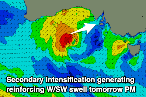
This swell will hold into tomorrow, (more to 3ft across Middleton) but we should see an additional pulse of W/SW swell for the afternoon, from the mid-latitude low itself as it projects a fetch of tight W/SW gales through our western swell window today.
This will likely push the Mid Coast more towards the consistent 3ft range into the afternoon, as Middleton holds around 3ft owing to the west nature of the swell. Expect less size in and around the Bay/Point.
Winds are tricky as the low pushes across us, bringing offshore E/NE winds on the Mid Coast tomorrow morning and N/NE breezes down South, giving into sea breezes ahead of a fresher S change into the late afternoon/evening. With this we should see quality waves across both coasts through the day.
Friday unfortunately looks poor as we fall under the influence of the western flank of the low, bringing strong S/SW winds, which may be S/SE for a period on the Mid Coast through the morning as sets ease from 2-3ft. These winds aren't expected to bring much in the way of windswell, just poor conditions.
The low will remain slow moving, maintaining strong but abating S/SW winds, swinging back offshore on Sunday across both locations (E/NE Mid Coast and N/NE South Coast).
We'll see a fun, though inconsistent SW groundswell in the mix of Saturday as the W/SW swell energy eases, generated by a strong but distant polar low over the last two days around and east of the Heard Island region. The low is currently weakening but with multiple fetches of broad gales aimed through our swell window, Middleton should come in around 3ft+, easing back from an inconsistent 3ft on Sunday morning. The Mid looks to only be 1-2ft on Saturday, tiny and to 1-1.5ft on the favourable parts of the tide.
A shallow trough will clip the region overnight Sunday, bringing variable winds into Monday morning and a further drop in size.
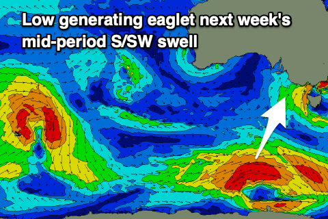
 We should see a fun new, mid-period S/SW swell arriving through the afternoon, generated by a small low developing south of the country on the weekend. It'll be fairly small in scope and short-lived, but should provide inconsistent 2-3ft sets across Middleton Monday afternoon and Tuesday morning.
With afternoon sea breezes Monday, Tuesday is the pick as the swell eases under a fresh E/NE-NE'ly. Not ideal but selected locations will be fun.
Longer term there's nothing too significant or major on the cards for the middle to end of next week and the following weekend. Therefore make the most of the coming waves and windows of clean conditions.


Comments
Beautiful sat image of the incoming low, drawing up cold, polar air.
Whoohoo, hopefully tomorrow will be awesome on the mid unless that low speeds up. Sunday looking good down South tho :-)
Should be fun, also the new swell has hit the Cape du Couedic wave buoy proper.
This spectral analysis also shows the three different swells in the water.
Each peak in red aligns with the period on the bottom, and the direction is the green line..