Fun waves across the South Coast over the coming days
South Australian Surf Forecast by Craig Brokensha (issued Wednesday August 25th)
Best Days: South Coast tomorrow morning, Friday and swell magnets early Sunday, Mid Coast for the keen Sunday afternoon and early Monday, South Coast Monday and Tuesday
Features of the Forecast (tl;dr)
- New S/SW groundswell for tomorrow with variable E/NE-NE winds, tending SE into the PM
- Easing S/SW groundswell Fri with mod-fresh N/NE tending NE winds, possibly variable late
- Fading surf Sat with fresh N/NE tending N/NW and then NW winds
- Mid-period W/SW swell filling in Sun with moderate W/NW-W winds
- Inconsistent W/SW groundswell Mon with N/NE tending N/NW winds on the Mid, N/NW all day down South
- Moderate sized+ swell for mid-late next week with winds out of the north
Recap
The Mid Coast provided really fun 2ft+ waves yesterday morning (under the expected 3ft sets) with a good W/SW groundswell and light winds, deteriorating into the afternoon with a fresh SW'ly before cleaning up late but also filling up.
This morning conditions are great again but the swell on the way out with glassy, 1-1.5ft sets.
The South Coast was sizey but poor yesterday with strong onshore winds, while today's we've got more variable winds (better than expected) and cleaner, lumpy surf easing from then 3ft+ range across the Middleton stretch.
This week and weekend (Aug 26 - 29)
Looking at the coming few days of surf and the South Coast should offer fun and improving waves with the arrival of a good, new, S/SW groundswell tomorrow, easing thereafter into Friday, bottoming out Saturday.
 The source of this groundswell was a robust polar frontal progression moving under the country the past couple of days. We might see some new, mid-period energy arriving later today down South with the peak due tomorrow to 3-5ft across the Middleton to Goolwa stretch.
The Mid only looks to come in at 1ft owing to the southerly swell direction.
Winds will be similar to this morning and variable out of the E/NE-NE tomorrow morning down South, creating some lump but clean faces, with moderate SE winds due into the afternoon. Friday looks better with the easing S/SW groundswell from the 3ft range on the sets across Middleton and N/NE tending NE winds, possibly variable late afternoon. This should provide a full day of good surf.
 Into Saturday offshore N/NE tending N/NW winds are due, then shifting NW later but with a fading 1-2ft wave across Middleton. Exposed breaks won't be too much bigger and likely 2ft+. Get in early before the swell bottoms out.
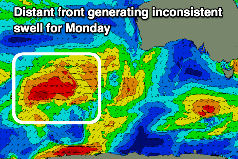
Moving into Sunday and a new, mid-period W/SW swell is due to fill in across both coasts, generated by a distant though strong polar low that's currently around the Heard Island region. This low will project W/SW gales up through our western swell window, weakening while passing under Western Australia Thursday (top right).
We should see mid-period W/SW swell building off the weakening stages of the front Sunday followed by less consistent groundswell Monday. The Mid Coast looks to reach 2ft through the day, holding a similar size Monday with the South Coast only building to 2ft+ across the Middleton stretch into the afternoon, holding a similar size Monday but inconsistent.
Winds on Sunday will favour the South Coast with the remnants of the swell producer pushing in from the west, bringing W/NW-W winds, not ideal with the lack of size and west swell direction down South.
 Monday looks much better with N/NW offshores all day down South, N/NE for a period in the morning on the Mid, creating workable, bumpy options.
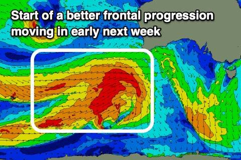
From Tuesday and more so Wednesday we're looking at some larger W/SW groundswell filling in, owing to a broad polar frontal progression firing up towards the country from the south-west of Western Australia.
The structure and timing of each front is still up for grabs but we're looking at at least moderate sized W/SW groundswell energy arriving Wednesday afternoon and peaking Thursday with favourable winds from the northern quadrant, but more on this in the coming updates.

