W/SW swells ahead of an upgraded S/SW groundswell
South Australian Surf Forecast by Craig Brokensha (issued Wednesday June 30th)
Best Days: Tomorrow both coasts, protected spots South Coast Friday but more so Saturday and Sunday morning, South Coast Monday, Mid Coast possibly Sunday morning
Features of the Forecast (tl;dr)
- New W/SW swell filling in tomorrow with NE tending N/NW winds on the Mid, NW all day down South
- Reinforcing W/SW swell for Fri mixed in with some local windswell. Strong W/SW winds (possibly W'ly at times down South), easing Sat
- Strong S/SW groundswell building late Fri, peaking Sat with fresh W/SW winds (W/NW during the AM down South)
- Easing mid-period S/SW swell Sun with W/NW tending SW winds, possibly variable early on the Mid
- Clean fading S swell Mon down South
Recap
Monday's strong pulse of S/SW swell dropped back through yesterday with the South Coast magnets offering up the best waves and conditions with all day offshore winds. Today the surf is tiny and near flat.
The Mid Coast was tiny yesterday but a slight pulse of swell has been seen today to 0.5-1ft, mixed in with a tiny NW windswell.
This week and next (Jul 1 - 9)
With the swell bottoming out today, we see our new mid-period W/SW swell filling in tomorrow, followed by a secondary pulse Friday.
 Tomorrow's first pulse was generated by a broad though not overly strong frontal system pushing up and into Western Australia, with the mid-period energy due to fill in tomorrow, likely undersized at dawn.
We should see the Mid Coast pushing to 2ft, with 3ft sets possible through the day, while the South Coast looks to reach 3ft across Middleton.
Winds look favourable for both coasts in the morning, NE on the Mid Coast and NW down South, shifting moderate N/NW across the Mid into the afternoon and holding from the NW down South.
We'll then see winds strengthen into the evening as an approaching cold front, come developing low move in, bringing a strong W/SW change Friday. The Victor region may see winds tending more W-W/NW at times but for the most part conditions will be bumpy and choppy.
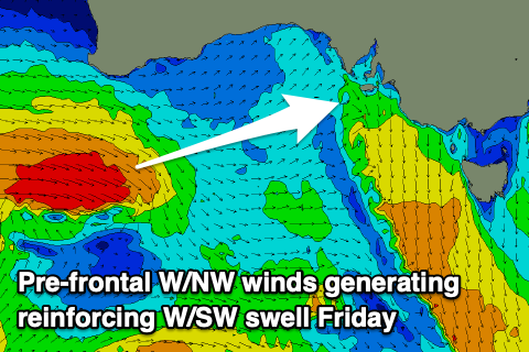
This front will bring an additional pulse of W/SW swell, generated under Western Australia today by pre-frontal W/NW gales, and then there'll also be some windswell in the mix as the front moves through.
The Mid Coast should continue around 2-3ft on the sets Friday, with the South Coast persistent at the 3ft range across Middleton, and inconsistent.
 We've now got a better pulse of S/SW groundswell for Saturday, generated as the low forms behind the front, with a tight but strong fetch of severe-gale S/SW winds now due to be projected towards us Thursday and Friday morning.
The size looks to be fairly decent, building late Friday to 4ft if we're lucky but peaking Saturday to the 5ft range. The Mid Coast looks to ease back more to the 2ft+ range with possibly 3ft sets at times on the magnets.
Due to the stalling nature of the low we'll unfortunately see fresh to strong W/SW winds persisting Saturday, though the Victor region will see morning W/NW winds, with Sunday likely to play out similar but with less strength.
A moderate W/NW tending SW breeze is due down South Sunday as the S/SW swell eases from a mid-period 4ft or so, with easing 2ft sets on the Mid. There's a chance for more variable winds on the Mid but we'll confirm this Friday.
Into next week we'll see the size drop away fairly rapidly as winds swing back to the N'th as a ridge of high pressure moves in from the west.
Unfortunately the combo of the stalling low, high moving in from the west and another mid-latitude low off Western Australia mean there's no real significant surf due into next week at all.
Conditions will be favourable under northerly winds but you'll have to hit up the swell magnets. More on this Friday.


Comments
When you say undersized at dawn down south on Thursday...what size? 2ft Middleton? Or smaller than that? Cheers!
Shouldn't be below 2ft from Day St hopefully.
Onya Craig...looks like my third dawn surf this week coming up!
How ya go? Looks glassy, small and fun on the right board.