Good surf from Sunday down South
South Australian Surf Forecast by Craig Brokensha (issued Friday June 18th)
Best Days: Mid Coast for the keen on the favourable parts of the tide tomorrow through Monday, South Coast Sunday through Wednesday
Features of the Forecast (tl;dr)
- Moderate sized, easing SW groundswell tomorrow with fresh to strong, though easing S winds
- Reinforcing SW groundswell Sun PM with N/NE-NE tending E winds
- Secondary reinforcing SW groundswell for Mon AM with N/NE tending E/NE winds, easing Tue with fresher N/NE-NE winds, smaller Wed with fresh N/NE winds
- New inconsistent SW groundswell for Fri but with a possible W/SW change
Recap
An early offshore wind around Victor yesterday morning with 2-3ft of swell, quickly giving into an onshore change as a trough pushed in from the west, linked to a broad mid-latitude low deepening in the Tasman Sea. The Mid Coast saw early light winds but deteriorated quickly with 2ft+ of choppy swell.
Overnight the state got a big soaking and this morning we've got strong onshore winds and a mix of windswell and new groundswell to 3-5ft down South, cleaner and to 2ft on the Mid Coast.
This week and weekend (Jun 19 - 25)
We'll see today's new SW groundswell easing back in size through tomorrow but winds will continue to spoil the South Coast with the western arm of the low aiming fresh to strong but easing S'ly breezes into us.
Size wise Middleton looks to ease from a bumpy and choppy 4ft, with the Mid seeing S/SE breezes but tiny 1-1.5ft leftovers.
From Sunday we'll see conditions improve as a high moves in from the west, but it'll be very slow moving owing to a mid-latitude low firing up across the southern region of Western Australia, stalling west of us most of next week.
Winds feeding in from the north-eastern quadrant will favour the South Coast Sunday through Friday as we see some initial reinforcing groundswell pulses Sunday and Monday morning, tailing off into the middle of the week.
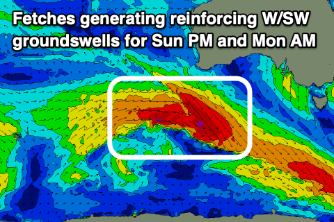
 The first pulse of reinforcing SW groundswell will arrive mid-late morning Sunday, generated by a patchy though good fetch of severe-gale to storm-force W/NW-W winds around a low that formed south-west of Western Australia mid-week.
Middleton should build to 3-4ft into the afternoon from a smaller 3ft in the morning while the Mid Coast looks to only be tiny and to 1-1.5ft through the afternoon.
A similar size, reinforcing pulse of SW groundswell is due Monday from trailing severe-gale W/NW winds stretching out under the country today and early tomorrow. This should keep 3-4ft waves hitting Middleton in the morning, smaller into the afternoon with 1-1.5ft sets on the Mid Coast.
Smaller surf should then be seen Tuesday, easing from 2-3ft across Middleton, 1ft on the Mid, smaller again Wednesday and Thursday.
Coming back to the local winds and a morning N/NE-NE offshore is due Sunday ahead of E'ly sea breezes, N/NE tending E/NE on Monday and fresher N/NE-NE on Tuesday as the mid-latitude low slowly edges closer to us from the west.
The low is due to weaken though and this will maintain fresh N/NE winds across the state Wednesday, stronger N'ly on Thursday before possibly bringing a W/SW change on Friday.
Into Friday a new, inconsistent SW groundswell from a polar low is on the cards but we'll confirm this Monday. Longer term it looks like we'll start to see some stronger mid-latitude fronts moving in at the end of the month, bringing windier, stormy conditions from the W/SW, but more on this Monday. Have a great weekend!

