Small, mixed weekend, more action next week
South Australian Surf Forecast by Craig Brokensha (issued Friday 30th April)
Best Days: South Coast tomorrow morning, Mid Coast for the keen Sunday afternoon, Mid Coast Monday afternoon and Tuesday, South Coast Thursday and Friday
Features of the Forecast (tl;dr)
- Easing SW swell Sat with strengthening N/NE tending N winds ahead of an evening W change
- New W swell Sun with moderate W/SW winds on the Mid, easing into the afternoon, W/NW in the AM down South
- Large SW groundswell building Mon with morning SE winds ahead of sea breezes, easing Tue with strengthening SE tending S/SE winds, smaller Wed with SE-S/SE winds
- New SW groundswell for Thu and Fri with N winds
Recap
The surf bottomed out into yesterday with small waves for the keen down South, tiny on the Mid Coast. A new, inconsistent W/SW swell filled in through the day across the Mid but we’re seeing a peak in energy today with inconsistent but clean 1-2ft sets, 2-3ft across the Middleton stretch down South.

Coupla runners this AM
This weekend and next week (May 1 - 7)
Today’s mix of swells should start to ease later this afternoon and further tomorrow as winds strengthen out of the north, bringing temperatures up further. Size wise we should still see 2ft sets across Middleton, with the Mid Coast becoming tiny. A fresh N/NE breeze will strengthen from the N’th through the day shifting W/SW likely on or just after dark as a front moves in.
This front will be linked to a weak mid-latitude low, with it looking to be less of a local swell producer. In saying this, a fetch of strong W/SW winds under WA today should kick up a small 1-2ft wave for the Mid Coast Sunday, tiny down South.
Winds in the wake of Saturday evening’s change look to be moderate out of the W/SW, easing into the afternoon with the South Coast seeing W/NW winds in the morning.
 Dawn Monday will start small but we’ll see our large, long-period SW groundswell starting to fill in through the morning, likely peaking late afternoon/into the evening.
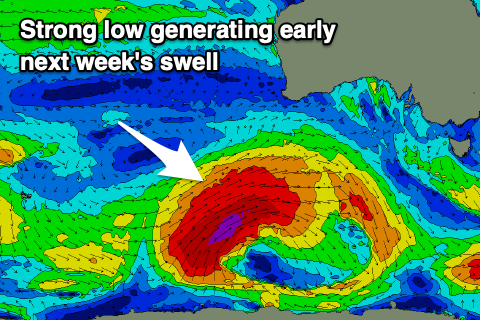
The low linked to this swell has formed just east of the Heard Island region and has been generating a fetch of severe-gale to storm-force W/SW winds through our distant swell window, with it due to now be strongest today south-west of WA, weakening slowly while projecting east tomorrow, breaking down Sunday.
A large, long-period SW groundswell will result, with it building strongly Monday afternoon, reaching 6ft across Middleton late with 8ft sets on the deepwater reefs. The early morning looks small and to 2ft. The Mid Coast should build to 2-3ft with the help in the incoming tide.
 Winds are tricky and the models are still moving around a touch with a tricky trough moving in Sunday evening but we’ll likely see moderate S/SE-SE winds down South, SE in the morning on the Mid but ahead of W/SW-SW sea breezes, improving late.
Easing surf from a similar if not slightly smaller size is due down South Tuesday morning (5-6ft Middleton), 2ft+ on the Mid Coast along with fresh SE tending S/SE winds as a ridge of high pressure slides in from the west.
This ridge will be squeezed by a low in the Tasman Sea, extending over Victoria bringing breezy SE-S/SE winds again Wednesday as the swell backs off, around to the N’th on Thursday with a new SW groundswell.
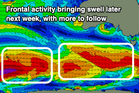
This new, moderate sized SW groundswell and a secondary pulse for Friday will be generated by a strong frontal progression moving in through next week. Pre-frontal W/NW gales will be followed by post-frontal gales, with the size look to come in at 3-4ft across Middleton but tiny and to 1ft+ across the Mid Coast. Winds look to shift from N/NW to W next Friday ahead of a weakening mid-latitude low, but more on this and the active outlook beyond on Monday. Have a great weekend!

