Fun swell to end the week, more activity from the weekend
South Australian Surf Forecast by Craig Brokensha (issued Wednesday April 28th)
Best Days: Late tomorrow on the Mid Coast for the keen, both coasts Friday, Saturday morning for the keen South Coast, Sunday morning Mid Coast, Monday afternoon and Tuesday Mid Coast, Wednesday down South
Features of the Forecast (tl;dr)
- Building mix of W/SW-SW swells tomorrow afternoon, peaking Fri with N/NE-N tending variable winds
- Easing SW swell Sat with strengthening N winds ahead of a late afternoon W change
- New W swell Sun with early S/SE winds on the Mid, W/SW-SW down South
- Large SW groundswell building Mon with SE tending strong S/SE winds, easing Tue with SE winds, smaller Wed with E/NE-NE morning winds
Recap
Great waves down South yesterday, still coming in at a fun 2-3ft across Middleton with clean conditions, fun into the afternoon with weak sea breezes, then down from a smaller 2ft today. The Mid Coast was tiny and to 1ft+ yesterday morning, back to 0.5ft today.
This week and weekend (Apr 27 – May 2)
A temporary low point is expected tomorrow morning ahead of our new inconsistent W/SW-SW swell into the afternoon, peaking Friday morning. The source of these mix of swell was a patchy though persistent frontal progression dipping south-east from a position west-southwest of Western Australia.
We'll see Middleton coming in at 1-1.5ft tomorrow morning, likely reaching 2ft into the afternoon and peaking Friday morning to 2-3ft. The Mid Coast should build to 1-1.5ft later tomorrow and hold a similar size Friday.
Winds tomorrow will be good in the morning but with the tiny swell down South, light N/NE-N ahead of sea breezes, then great Friday and N/NE-N tending variable.
Looking at Saturday, the swell will be on the way out, easing from 2ft across Middleton and tiny on the Mid with a strengthening N'ly wind ahead of a late afternoon W'ly change.
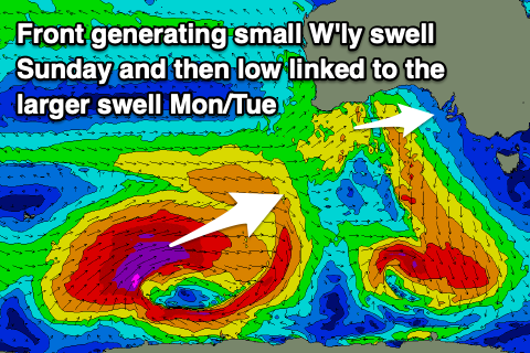
This change will be attached to a weak mid-latitude front and will bring a small 2ft of W'ly swell for the Mid Coast Sunday, tiny down South along with a W/SW-SW breeze down South, likely tending S/SE early on the Mid but we'll confirm this Friday.
Next week onwards (May 3 onwards)
 Monday dawn will start slow but during the morning a strong, long-period SW groundswell will start to build. The source of this swell will be a strong polar low firing up around the Heard Island region this evening, generating a great fetch of severe-gale to storm-force W/SW winds while moving slowly east through our swell window.
The low will continue with strength until south of WA Saturday morning, then easing while continuing slowly east. This will result in a large SW groundswell, with it building strongly Monday afternoon, peaking late in the day to 6ft+ across Middleton with 8ft sets on the deep water reefs. The Mid Coast should see surf building to 2-3ft and winds will be SE in the morning, shifting strong S/SE into the afternoon as a ridge of high pressure moves in.
The swell will still be large and easing from the S/SW on Tuesday as winds persist from the SE, E/NE-NE Wednesday morning.
Longer term a secondary, long-period and less consistent W/SW groundswell is due late week, but we'll have a closer look at this Friday.


Comments
Had fun surf on the mid later this afternoon, great to see good swell on both coasts this time of the year-Dannyboy
Noice, and fun today as well.