Small swells and light winds
South Australian Surf Forecast by Craig Brokensha (issued Friday March 19th)
Best Days: South Coast magnets Saturday, Sunday and Monday mornings, Mid Coast later today and for beginners tomorrow, Mid Coast Tuesday
mornings
Features of the Forecast (tl;dr)
- New S/SW groundswell building this afternoon, easing Sat
- Fun, inconsistent W/SW swell building later this afternoon, easing Sat
- Light, variable (tending locally offshore winds?), ahead of sea breezes Sat and Sun
- Fading surf Mon with variable morning offshore winds ahead of sea breezes.
- New, inconsistent W/SW swell for Tue but with SE tending SW winds
Recap
Light winds and fun surf yesterday morning with clean 2ft waves across Middleton, similar this morning though a little lumpier with a variable wind out of the south.
The Mid Coast has been tiny to flat and a small increase in new W/SW swell forecast for this afternoon might be running a little late. Cape du Couedic has just perked up so keep an eye on tings late afternoon/evening.
This weekend and next week (Mar 20 - 26)
The slightly delayed W/SW groundswell due this afternoon should hopefully push to 1-2ft on the swell magnets by this evening across the Mid Coast (though with a big high tide), while on the South Coast our new S/SW groundswell should start also kicking in size with 3ft sets due across Middleton.
Both swells are expected to ease into tomorrow, dropping from an inconsistent 2-3ft across Middleton, while a reinforcing swell should keep the Mid around 1-1.5ft all day on the favourable parts of the tide.
Winds will be favourable for both coasts each morning on the weekend, variable and tending locally offshore ahead of afternoon sea breezes.
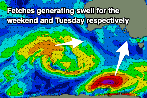
 Down South, into late Saturday and more so Sunday morning, a small reinforcing S/SW groundswell is due from a smaller, later forming low in our swell window (compared to the 'bombing' low bringing late today's swell) and this should just keep small, inconsistent 2ft sets hitting Middleton (tiny on the Mid Coast). With the southerly direction exposed beaches won't be too much bigger.
Monday will be nice and clean again but the swell tiny and fading from 1-1.5ft across Middleton.
Into Tuesday, the Mid Coast should see an inconsistent W/SW groundswell filling in, generated in our far swell window from a mid-latitude frontal progression pushing up from the Heard Island region towards Western Australia.
The swell will be inconsistent but should arrive overnight Monday and peak Tuesday to 1-2ft on the Mid Coast and we've now got a period of more favourable winds in the morning. A light SE'ly is due ahead of a trough and SW change, initially weak and then stronger Wednesday.
The trough will then precede a low, though the swell generating properties of this low are minimal. We'll see a short-lived fetch of strong S/SW winds aimed mainly in the South Coast's swell window, producing a kick in size Thursday to 3ft+ across Middleton but with SW tending S winds. Friday may be cleaner as the swell eases.
Longer term we may see some better swell producing systems firing up next weekend, but more on this Monday. Have a great weekend!

