Generally poor with a couple of small windows of clean surf
South Australian Surf Forecast by Craig Brokensha (issued Friday January 29th)
Best Days: Monday morning South Coast, Thursday morning South Coast
Features of the Forecast (tl;dr)
- New, inconsistent SW groundswell building Sat PM, peaking early Sun, then easing but with onshore SE tending S/SE winds
- Easing SW groundswell Mon with variable winds ahead of a late morning SW change
- Reinforcing SW swell for Tue but with strong S winds
- Localised S swell Tue/Wed, easing and cleaner Thu AM
Recap
Improving conditions and a fun S/SE swell yesterday with options across the coast for the keen and savvy, poor today with the swell bottoming out and early variable winds ahead of a stronger onshore change. The Mid Coast has been tiny to flat.
This weekend and next week (Jan 30 – Feb 5)
The start of the weekend isn't anything to write home about with a low point in swell along with fresh S'ly in the wake of today's trough. Into the afternoon though, our new, long-period and inconsistent SW groundswell should start to fill in.
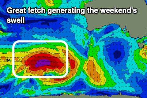
 This swell has filled in strongly across Western Australia today and looking at the size, I'm now confident there'll be a few bigger sneakers in the mix at its peak in size early Sunday. The swell was generated by a strong polar low in the Heard Island region earlier this week, with it due to arrive tomorrow morning, building strongly into the late afternoon and evening. Middleton should reach 3-4ft+ by dark, with a peak likely overnight, easing from 3-5ft Sunday morning.
The Mid Coast will likely be around the 1ft+ range later tomorrow and Sunday morning, suited to beginners.
Winds will remain poor and fresh from the SE across the South Coast Sunday morning, possibly tending E/SE at times) ahead of S/SE sea breezes.
Our window of more variable winds Monday morning is still on track with the swell easing back in size to 2-3ft or so across Middleton. This variable breeze will be head of another trough, bringing a strong SW change late morning, so get in before then.
 Our reinforcing pulse of SW groundswell for later Monday and Tuesday is on track, but we'll also see a local, stormy S'ly swell in the mix (discussed below).
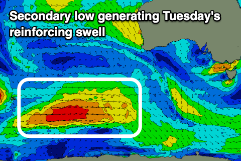
The reinforcing swell was generated by a secondary, more distant polar low firing up the back of the strong system linked to the weekend's swell. This low is currently weakening south-west of Western Australia but will maintain a fetch of strong, broad W/SW winds through our swell window on the weekend, followed by a secondary front pushing through Sunday/Monday.
The swell should keep Middleton around 3ft+ Tuesday morning with 1-1.5ft sets on the Mid Coast, but the secondary front pushing through Sunday/Monday is due to form into a low to the south of us. This will bring strong S/SW winds and a localised, poor quality S'ly swell on top of the groundswell lifting the size to 3-4ft or so.
Conditions will consequently be poor with a strong S'ly breeze, S/SE and back to fresh Wednesday as the swell eases.
Into Thursday we'll fall temporarily between weather systems, with another low forecast to form south-west of us, but this will tip winds NW through the morning. A window of clean conditions is expected with a mix of swells to 2-3ft or so. The Mid Coast looks to remain tiny.
This secondary low may stall in the Bight, bringing a mix of W/SW-SW swells late week along with onshore winds, but we'll review this Monday. Have a great weekend!


Comments
The horror
... continues
crap
Worst summer in memory!
Summer time slops
Might be time to take up golf