Plenty of south swell, cleanest once it fades
South Australian Surf Forecast by Craig Brokensha (issued Monday January 18th)
Best Days: Keen surfers down South Wednesday, swell magnets down South Thursday morning, South Coast Saturday/Sunday mornings
Features of the Forecast (tl;dr)
- Over-forecast size Tue/Wed
- Late increase in S/SW groundswell tomorrow with SE tending S/SE winds, easing Wed with E/NE tending SE winds
- Cleaner, fading surf Thu AM for the magnets
- New, inconsistent SW groundswell Sat with NE tending SE winds, easing Sun with N/NE tending N/NW, then W/NW winds
Recap
Plenty of swell Saturday but with a fresh onshore wind down South, only for the keen. Sunday saw plenty of surf but winds continued to blow onshore, with a late spike in new mid-period S/SW swell which has held into this morning around 3-4ft. Winds have remained onshore though and it's only for the keen.
The Mid Coast was better Saturday morning with 1-2ft waves for the keen, tiny yesterday and flat today.
This weekend and next week (Jan 19 - 24)
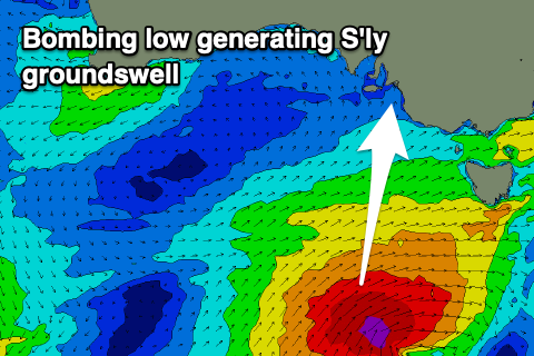
The current southerly swell energy is from a series of polar fronts forming and projecting up and across Tasmania under the influence of the Long Wave Trough (LWT). The LWT is currently pushing east and into the Tasman Sea, but one final and significant storm will develop under its spell.
 This is a 'bombing low' (that being the rapid intensification and deepening of central pressure, dropping just over 24hPa in 24 hours), developing just within our swell window, south-west of Tasmania today.
We're seeing a fetch of gale to severe-gale S/SW winds projected just within the South Coast's swell window, with the swell due to arrive later tomorrow afternoon down South, peaking overnight before easing Wednesday.
Size wise the South Coast looks to be generally around 3ft tomorrow morning across Middleton, kicking late to 4ft, then easing back rapidly from 3-4ft on Wednesday morning. With the southerly swell direction, the Mid Coast will remain tiny to flat and unsurfable.
It's worth noting our models are incorrectly combining the mid-period and stronger groundswell energy, over-forecasting the size down South through tomorrow and Wednesday.
Looking at the local winds and tomorrow will remain poor with fresh SE tending stronger S/SE winds, better though still hit and miss Wednesday with a morning E/NE breeze. Protected spots should be OK for a wave through the morning.
Thursday looks straighter with a variable N'ly offshore but the swell will be minimal and fading from 1-2ft across Middleton. Variable winds are likely again Friday morning but the swell will be at a low point and tiny.
As touched on in Friday's update, we've got a small lift in swell for the weekend and with favourable winds. A relatively weak and small polar low will push through our swell window over the coming days, forming east of the Heard Island today. A fetch of strong to sub-galeforce W'ly winds are forecast today and tomorrow, weakening Wednesday, producing an inconsistent swell that should arrive later Friday but peak Saturday with good 3ft sets across Middleton, tiny and to 0.5ft on the Mid.
Conditions look favourable both mornings with a light NE breeze Saturday, N/NE tending N/NW on Sunday ahead of a trough and as the swell eases.
Longer term there's nothing too significant on the cards and winds look to revert back to the S/SE mid-week, but more on this Wednesday.

