Slim pickings into the end of the year
South Australian Surf Forecast by Craig Brokensha (issued Monday 21st October)
Best Days: Mid Coast for the desperate late tomorrow and Wednesday morning, South Coast Friday morning
Features of the Forecast (tl;dr)
- New SW swell building Tuesday, easing Wednesday with poor winds for the South Coast, small to tiny on the Mid though surfable
- New mid-period SW swell for Thu PM/Fri as winds improve for the South Coast Fri AM
Recap
Poor surf to start the weekend across the South Coast, while Sunday offered fun, peaky waves on the magnets with a new S/SW swell providing 3ft sets. The Mid Coast remained tiny to flat.
Today the Mid Coast is still flat and the South Coast, onshore and small.
This week and weekend (Oct 22 - 26)
Yesterday morning’s window of cleaner conditions was unfortunately the best window of surf until the coming Friday.
The Southern Annular Mode, an index linked to how far north or south of normal the westerly storm track sits is strong positive, keeping the storm track retracted to the south and subdued.
This also sees high pressure move in across our main swell windows, putting a block on any major activity while also bringing onshore winds from the south to south-eastern quadrant.
So looking at what we do have on the cards, and our new SW swell is due to fill in tomorrow, generated by a good, though weakening low through our far-medium swell window last Friday through the weekend.
The position of the low wasn’t ideal for the Mid Coast, but we should still see a kick in size to 1-2ft through the afternoon, easing from 1-1.5ft on Wednesday. The South Coast should see building surf to 3-4ft across Middleton through the afternoon, though both coasts will be poor with a fresh S/SW breeze, tending S/SE on dark on the Mid. So for the desperate the late session on the Mid looks the pick.
 Cleaner conditions should be seen on the Mid Wednesday with the tiny swell, S/SE through the morning ahead of SW sea breezes. The South Coast will remain poor with easing 3ft+ sets across Middleton.
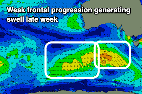
Into the end of the week a new mid-period SW swell will build through Thursday, hold Friday, generated by a weak frontal progression moving in from the Southern Ocean over the coming days.
A weak fetch of W/NW followed by W/SW winds should produce a slight kick back to 2-3ft across Middleton, tiny and to 1ft on the sets across the Mid Coast.
Winds will persist out of the S/SE on Thursday, while Friday morning is the pick of the week with winds shifting to the E/NE creating peaky, fun waves in protected spots (the pick of the week)
Moving into the weekend, a trough looks to bring onshore winds from the S’th back to the South Coast though without too much strength, along with small, easing levels of S/SW swell from 2ft. The Mid Coast will be tiny.
Another trough moving in Sunday will bring stronger S’ly winds after a possible variable breeze at dawn, but the swell will be small and to 2ft or so. We’ll confirm this Wednesday.
Longer term a new mid-period swell is likely early next week but with onshore S’ly winds, with a possible stronger swell late week, though more on this in the coming updates.


Comments
Disastrous outlook. But it's 2020 so this is to be expected!
Too true!