Poor outlook continues
South Australian Surf Forecast by Craig Brokensha (issued Wednesday 16th October)
Best Days: Sunday morning South Coast
Features of the Forecast (tl;dr)
- Generally small, weak swells with a couple of windows of lighter winds in the mornings (Sat/Sun)
- Stronger swell due Tuesday/Wednesday but winds look to be onshore down South, with small waves on the Mid
Recap
Poor conditions with strong onshore winds down South and no size across either region yesterday, while today there’s been a lift in swell across both coasts.
The South Coast is seeing a low quality and junky mix of windswells to 2-3ft, while the Mid Coast is picking up 1.5ft sets out of the W/SW though masked by the big morning high tide.

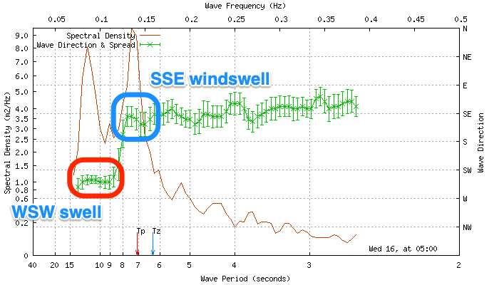
You can see the swells clearly on the Cape du Couedic wave spectral analysis with the W/SW energy spike around 12s, and the S windswell at a lower 7-8s. If it weren’t for the large outgoing and small incoming tide today the Mid would have been a fun 2ft but it’s alas on the tiny, teasing side of the coin and mostly 1-1.5ft with the rare bigger one.

Swell, though hindered by the high tide.
This week and weekend (Oct 17 - 20)
Looking at the end of the week, we’ll see today’s pulse of W/SW swell on the Mid Coast dropping right back overnight, with tiny, full 0.5-1ft sets max left tomorrow. The source of the swell was a short-lived low under WA earlier this week, hence the swell fading overnight.
Winds will also tend back to a strong S/SW’ly across both regions (early S/SE on the Mid) as a weak front pushes up towards us, creating poor conditions along with small, weak levels of S/SW and S’ly windswell.
Friday remains a lay day with fresh but easing S/SW winds and no decent quality swell.
Moving into the weekend we should see cleaner conditions develop through Saturday morning as winds ease and tend light E/SE across the South Coast, but the swell will be at a low point.. tiny, weak and 1-1.5ft across Middleton. The Mid Coast will be tiny to flat.
A slightly better, though still weak and small mid-period S/SW swell is due to fill in Sunday, generated by a weak polar front that’s currently south-southwest of Western Australia. The fetch strength is minimal but it projects slightly towards us today, producing a small spike in swell that should build to 2ft to maybe 3ft across Middleton, flat on the Mid Coast.
Conditions look better as winds swing to the E/NE through the morning, creating peaky, workable options for keen surfers, but by the time the swell peaks into the afternoon, S/SE sea breezes will be back in.
Monday looks dicey as the mid-period S/SW swell eases along with S/SW winds.
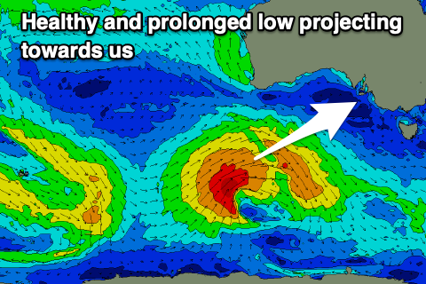
Moving into next week, and the stronger polar low discussed in Monday’s notes is still on the cards, with it forming north of the Heard Island region tomorrow. It’ll be tight and small at first but push east while generating a healthy fetch of strong to gale-force W/SW winds through our swell window while tracking east-northeast. The low will weaken while approaching us, clipping the state Monday evening as a trough, bringing a change in winds.
 The low will just be south of our western swell window, but still provide some small surf on the Mid Coast when the swell fills in Tuesday, building to 1-2ft through the afternoon, fading Wednesday. The South Coast should build to a good 4ft across Middleton, but gusty S/SE winds in the wake of Monday’s change will favour the Mid.
Longer term there’s no improvement in the outlook for the South Coast, but more on this Friday.


Comments
Swell has filled in nicely..