Easing mix of east and south swells as winds slowly improve

South Australian Forecast by Craig Brokensha (issued Monday 7th December)
Best Days: Mid Coast tomorrow morning, South Coast Wednesday morning, South Coast Saturday morning
Recap
Strengthening winds and a low point in swell didn't allow for much of a wave on Saturday, while the swell kicked into Sunday but with choppy conditions down South, 3ft on the Mid Coast for the desperate.
Today the South Coast has more size but conditions are still poor with the strong onshore wind, with sloppy 3ft surf on the Mid Coast.
This week and weekend (Dec 8 - 13)
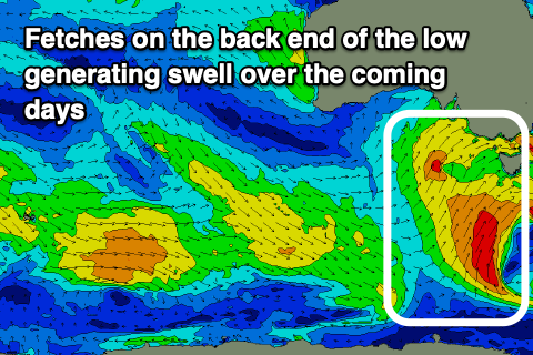
The windy, weekend of swell which has continued into today was generated by a slow moving and strong mid-latitude low which is now weakening while pushing slowly across Tasmania and Victoria.
With this we'll see the W/SW energy easing quick then the southerly swell energy from the backside of the low, which is still being generated today. A good fetch of strong to gale-force S'ly winds were being just on the edge of our swell window last night and this morning, but this has since now moved under Tasmania.
 The swell from this source is expected Wednesday, with tomorrow seeing easing sets from the 4ft range across Middleton, while the Mid Coast should drop back from 2ft in the morning. The S'ly swell Wednesday looks to come in around 3ft across Middleton in the morning, easing through the day and bottoming out Thursday morning.
Conditions tomorrow will still be average and onshore across the South Coast with a moderate to fresh SW'ly, easing through the day. The Mid Coast should see early S/SE-S winds, shifting onshore thereafter and holding until near dark.
Wednesday looks much better down South with a swing in winds around to the N/NE ahead of afternoon sea breezes. The Mid will also be much cleaner with an E/NE offshore but the swell looks to drop back to a tiny 1ft+.
Wednesday's sea breeze will be timed simultaneously with a surface trough pushing in from the west, and behind this we'll see a strong high move slowly east.
This will bring poor and strengthening SE tending S/SE winds to the South Coast on Thursday, kicking up a building S/SE windswell, while the Mid Coast looks to become flat.
Some new mid-period S/SW swell should be seen Friday on the South Coast, generated by a weak front attached to the trough moving through Wednesday afternoon. With winds falling well below gale-force we'll be looking at a weaker, mid-period S/SW swell to 3ft+ across Middleton, with the Mid Coast remaining tiny to flat. Conditions will remain poor though with a gusty E/SE breeze Friday morning down South, S/SE into the afternoon.
The weekend (Saturday) looks much better for waves as the high continues east, swinging winds E/NE-NE Saturday morning and NE Sunday morning. The S/SW swell will be on the ease though with fading 2-3ft sets across Middleton Saturday, tiny Sunday.
Longer term there's nothing too major at all on the cards as the positive Southern Annular Mode event keeps the westerly storm track subdued and close to Antarctica, but we'll have a closer look at this Wednesday.