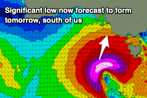
Strong low set to deepen south of us
South Australian Forecast by Craig Brokensha (issued Monday 30th November)
Best Days: Protected spots down South tomorrow morning, both coasts for keen surfers Wednesday (experienced down South), Thursday morning both coasts, beginners on the Mid Friday
Recap
The weekend's tricky wind outlook for Saturday was just that with a light dawn onshore, freshening through the morning along with a drop in swell from late last week. The Mid Coast was cleaner but only 1ft or so.
Yesterday was poor across all locations with strong onshore breezes and choppy surf.
Today some new mid-period SW swell has filled in and conditions are much better down South with a light offshore N'ly wind, clean and tiny to 1ft on the Mid Coast again. We should see the odd 1.5ft'er on the incoming tide this afternoon.
This week and weekend (Dec 1 - 6)
Today's building mid-period energy was generated by a broad, though relatively weak frontal system spawning off a polar low that formed south-west of Western Australia last Friday.
This swell is due to hold tomorrow morning, mixed in with a less consistent and stronger pulse of SW groundswell from the polar low with sets to 3ft+ across Middleton. Strengthening W/NW winds ahead of a vigorous cold front and deepening low will shift W/SW into the afternoon while at the same time kicking up a building stormy windswell to 2-3ft through the day.
The strengthening frontal system is now forecast to be quite a significant low pressure system, with cold air advected up from polar latitudes set to collide with warm, moisture laden air drawn down from the north, resulting in the formation of a deep low late in our swell window.
Just south of us tomorrow we'll see a strengthening fetch of severe-gale SW winds, with S/SW winds wrapping around the south-western flank. This will be late in our swell window, but we'll still see a large, long-period S/SW groundswell developing for Wednesday, building rapidly and peaking late afternoon.
 The morning down South looks to be around 4-5ft, with the swell kicking to 6ft+ through the afternoon across Middleton with larger sets on the deep water reefs. The Mid Coast should ease back from 2-3ft with workable conditions under a moderate to fresh S/SW-S breeze that should go SE near dark. The South Coast will be bumpy and average all day but there'll be options with the large swell.
Thursday looks much cleaner as winds swing around to the NE down South, E/NE on the Mid with easing surf from 4-5ft across Middleton, small to tiny and 1.5ft to possibly 2ft on the Mid Coast.
A small reinforcing W/SW swell should keep 1-1.5ft waves hitting the Mid Friday, with the South Coast holding a small 2ft, and winds are a little tricky but could be variable in the morning for both regions ahead of sea breezes.
Moving into the weekend and a strengthening cold front pushing up and across us Saturday is due to deepen into a low over Victoria, but this is too late to generate any decent swell for us.
Instead we'll see some weak windswell building Saturday afternoon, easing Sunday with onshore winds, but more on this Wednesday and Friday.

