Dynamic period ahead with no lack of swell
South Australian Forecast by Craig Brokensha (issued Friday 6th November)
Best Days: Beginners Mid Coast tomorrow Saturday and Sunday, South Coast for the keen Sunday morning, South Coast Monday and Tuesday morning, Mid Coast for solid onshore waves Thursday afternoon, both coasts Friday
Recap
Plenty of swell down South yesterday and today but strong onshore winds created poor conditions, weaker this morning and more organised. The Mid Coast was a slow 1-2ft and cleanest early and late yesterday, back to 1-1.5ft this morning.
This weekend and next week (Nov 7 - 13)
We've got lots of swell on the way for the weekend but initially winds will be average for the South Coast, improving from Sunday but best early next week.
The swell will have more of a south direction, spreading up from strong frontal activity through the Southern Ocean, south of the country so the Mid Coast will be mostly tiny but ideal for beginners with 1ft+ sets.
Looking down South and a reinforcing pulse of S/SW swell from a polar front moving through our swell window yesterday should maintain 3ft to occasionally 4ft sets across Middleton, though winds will be average and conditions poor with a fresh E/SE breeze, shifting more SE into the afternoon.
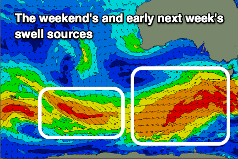
 Into the late afternoon a good new pulse of S/SW groundswell is due from a broad, elongated polar frontal system that's currently pushing under us (towards Tasmania).
The swell from this storm should kick to 4ft+ across the Middleton stretch later in the day, easing back from the 4ft range Sunday morning.
Winds should improve on Sunday and swing E/NE-NE down South, though with the onshore surf from the last few days, it'll take a while to clean up. Also with this size Middleton will be hard work and the more exposed beaches chunky.
Early next week looks much better, with the easing trend in swell slowed by the wagging tail of the strong frontal progression currently passing to our south.
Middleton is likely to still see 3ft to possibly 4ft sets early Monday, dropping through the day, down from 2ft+ Tuesday morning. The Mid Coast will become tiny to flat and unsurfable.
An approaching and strengthening mid-latitude low will squeeze a high to our south-east, bringing fresh NE winds on Monday, tending more variable into the afternoon, then stronger N/NE on Tuesday as the low nears.
Wednesday looks to be a lay day as the swell bottoms out under strong to possibly gale-force N/NW winds, whipping up a stormy windswell on the Mid Coast to 2-3ft into the afternoon.
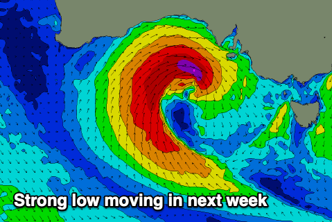
 This low now looks quite significant with it due to form south of WA on Tuesday, moving slowly east while projecting a fetch of severe-gale W/SW winds through our western swell window.
The low is forecast to slowly weaken on approach, with it passing across us Thursday, bringing a strong but easing W/SW tending SW change.
A large W/SW groundswell will fill in Thursday, likely coming in at 3-4ft on the Mid Coast, though with the westerly direction the South Coast looks sheltered from Kangaroo Island and only likely to build to 4ft or so.
With the low clearing to the east Friday winds will hopefully become variable with the easing W/SW swell and good to great conditions on the Mid Coast. We'll confirm this Monday, have a great weekend!

