Good swells from late week, into the weekend
South Australian Forecast by Craig Brokensha (issued Monday 2nd November)
Best Days: Mid Coast Thursday and for the keen Friday on both coasts, South Coast for the keen Sunday morning but more so Monday/Tuesday next week
Recap
A bumpy, OK wave to 1-2ft across the Mid Coast Saturday for the keen, the best of both regions with poor, onshore surf down South.
Sunday was clean but tiny on the Mid, while it was a touch cleaner in protected spots down South but small to tiny.
Today the surf has cleaned up but bottomed out with tiny waves, best suited to the South Coast swell magnets.
This week and weekend (Nov 3 - Nov 8)
There'll be nothing to surf over the coming two days as the swell bottoms out and winds freshen from the N'th tomorrow, giving into a strong S/SW change through Wednesday as a trough moves through.
Later in the day our new long-period, inconsistent SW groundswell should start building, with a peak expected on Thursday.
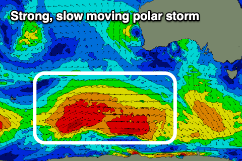
This swell started to be generated through our far swell window, around the Heard Island region on the weekend with a broad polar low generating a slow moving fetch of W/SW gales.
 The low is currently on the polar shelf, south-west of WA and continuing to generate W/SW gales, with it due to weaken very slowly this evening will moving further east.
A secondary weaker polar front is now forecast to move in behind the low, generating a fetch of strong W'ly winds and reinforcing SW swell for Friday.
We should see a moderate sized + SW groundswell event with a bit of longevity, filling in Thursday and easing slowly Friday.
Size wise the Mid Coast should see building surf to 2ft through the day, if not from early morning, holding and then easing from an inconsistent 1ft to maybe 2ft Friday.
The South Coast should provide strong 4ft+ sets across Middleton most of Thursday easing a touch back to 3-4ft on Friday.
Unfortunately in the wake of Wednesday's change, strong, but abating S'ly winds are due on the South Coast, S/SE-S on the Mid Coast, likely tending S/SW for a period and back to the S/SE late.
Therefore semi-protected spots will be the go on the Mid.
Friday looks clean on the Mid through the morning with a SE'ly ahead of SW sea breezes, with the South Coast OK during the morning as winds ease and become light to moderate out of the S'th.
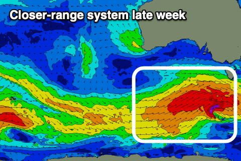
 Into the weekend, a new S/SW groundswell is due, generated by a strengthening frontal system under the country late week. A great fetch of W/SW gales will be generated on top the active sea state ahead of it, drawn out through our southern swell window, kicking the South Coast to 4ft+ through Saturday afternoon, easing from a similar size Sunday morning.
The Mid will be tiny and to 1-1.5ft owing to the southerly direction of the swell but winds will unfortunately only favour the gulf, fresh to strong from the S/SE on Saturday, possibly tending fresh E/NE on Sunday morning, but we'll confirm this Wednesday.
Early next week looks best for the South Coast as the swell eases and winds shift north-east, but more on this next update.


Comments
I know it is this time of the year but seriously FCK these south easterlies!
This will only get worse old mate.
La Nina is always crap.