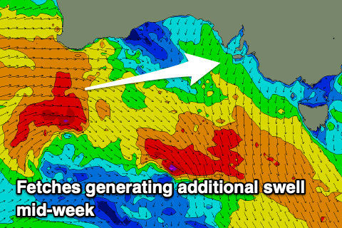
Continuation of westerly pulses
South Australian Forecast by Craig Brokensha (issued Monday 7th September)
Best Days: Mid Coast Wednesday, both coasts Thursday, early Friday Mid Coast, South Coast Friday, South coast Saturday, Mid Coas Sunday
Recap
Great waves across the South Coast Saturday with a new groundswell to 3-4ft across the Middleton stretch with variable NW winds, clean on the Mid Coast also and to 2ft to occasionally 3ft.
The swell eased back through yesterday from a great, clean 2-3ft down South, bumpy on the Mid and tiny with the odd set for the desperate.

Mid Coast Saturday AM
Today the South Coast is smaller but fun across the Middleton stretch for bigger boards, better at Waits and Parsons. The Mid Coast is tiny.
This week and weekend (Sep 8 – 13)
Today's increase in northerly winds are linked to a broad though weakening mid-latitude frontal progression moving in from the west and with this we'll see the W/SW mid-period and groundswell energy following through tomorrow and Wednesday.
From late last week through the weekend a broad and strengthening frontal progression in the south-east Indian Ocean generated an inconsistent but good W'ly groundswell that will favour the Mid Coast over the South Coast.
 The remnants of the progression moving under WA last night and today is seeing additional strong to gale-force W'ly winds through our western swell window, producing some additional mid-period energy.
We should see the mid-period and groundswell energy building through the afternoon, small to tiny early but a change this evening will leave lingering SW winds across the South Coast, possibly light S'ly for a period on the Mid Coast before reverting back to the SW.
An afternoon increase to 2ft is due on the Mid Coast by late, with Wednesday offering 2ft to occasionally 3ft sets on the swell magnets and across the favourable parts of the tide.
The South Coast isn't expected to see much over 2-3ft across Middleton later in the day, peaking around 3ft Wednesday with the odd bigger one towards Goolwa.
Winds are still looking best for the Mid Coast Wednesday and out of the SE.
Thursday will become cleaner down south as winds shift around to the NE, favouring selected breaks as the swell eases from an inconsistent 2-3ft across Middleton and 2ft on the sets across the Mid Coast.
 Reinforcing pulses of W/SW groundswell are due Friday and then again Saturday afternoon/Sunday from following fetches and frontal systems continuing to fire up towards Western Australia. Friday's will be the smallest and should keep inconsistent 1-2ft sets hitting the Mid Coast, small down South, while the weekend's will be bigger, produced by a fetch of gale to severe-gale W/SW winds through the south-east Indian Ocean today and tomorrow.
We'll see this building surf through later Saturday and reaching an inconsistent 2ft late but peaking Sunday to 2ft+ on the Mid Coast with the South Coast seeing infrequent 2-3ft sets.
Winds on Friday will persist out of the N/NE-NE, favouring the South Coast with more variable winds on Saturday as a trough pushes through, S/SE tending S/SW on Sunday.
Longer term it looks like we'll finally see a closer and more significant polar frontal progression firing up under the country through the weekend and early next week, generating larger, consistent surf for the state. More on this Wednesday.


Comments
The new swell is showing nicely..